Ataíde
| Ataíde | ||||||
|---|---|---|---|---|---|---|
|
||||||
| Basic data | ||||||
| Coordinates : | 41 ° 15 ′ N , 8 ° 12 ′ W | |||||
Ataíde is a place and a former municipality in northern Portugal .
Ataíde belongs to the Amarante county in the Porto district . The community had an area of 1.61 km² and 1002 inhabitants (as of June 30, 2011). Together with the former communities of Real and Oliveira , Ataíde forms the small town of Vila Meã, which was elevated to Vila in December 1987 .
On September 29, 2013, the municipalities of Ataíde, Real and Oliveira were merged to form the new municipality of União das Freguesias de Real, Ataíde e Oliveira .
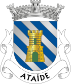
coat of arms
In blue four silver diagonal bars on which a golden tower with a four-pinnacle wreath and green gate and a window stands. A three-tower wall crown rests on the shield . In the white band at the base of the shield, the place name in black letters "ATAÍDE".
Individual evidence
- ^ Publication of the administrative reorganization in the Diário da República gazette of January 28, 2013, accessed on October 1, 2014
Web links
- Map of the Freguesia Ataíde at the Instituto Geográfico do Exército
- Information about Ataíde. amarante.pt, accessed June 12, 2011 (Portuguese).


