Atlas Suvorov

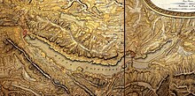
Excerpt from the Suworow Atlas with Lake Zurich
The atlas Suworow (official title: Atlas of the campaign of the imperial Russian troops in Switzerland ) consists of seven maps, which were created after the alpine campaign of the Russian army under Alexander Wassiljewitsch Suworow in 1799. They show the battles and the marching routes through the eastern part of Switzerland (today's cantons of Ticino, Graubünden, Uri, Schwyz, Glarus, St. Gallen, Zurich and Aargau) and were presented to Tsar Alexander I as a gift in 1804 . The place names are therefore given in Cyrillic script. The topographical information is based on the Atlas Suisse; In contrast to that, the atlas Suworow is colored. Some maps are not facing north.
literature
- Atlas Suworow: Atlas of the campaign of the imperial Russian troops in Switzerland until 1799. Facsimile edition. Edited by Arthur Dürst . Zurich: Werd, 2000. ISBN 978-3-85932-313-1
- Arthur Dürst. The atlas Suvorov . Cartographica Helvetica 21 (2000) pp. 3-16.
- Arthur Dürst. Atlas Suworow: The cartographic requirements and consequences of the campaign of 1799 in Switzerland. Zurich: Matthieu, 2000. ISBN 9783952193600
Web links
Commons : Atlas Suvorov - collection of images, videos and audio files
