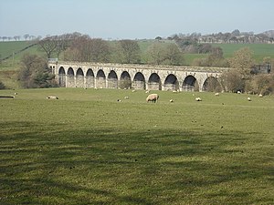
Avon Viaduct (Westfield)
Coordinates: 55 ° 56 ′ 5 " N , 3 ° 42 ′ 27" W.
| Avon Viaduct | ||
|---|---|---|
| use | Railway bridge | |
| Convicted | Monkland Railway | |
| Subjugated | Avon | |
| construction | Stone arch bridge | |
| overall length | 201 m | |
| Number of openings | 16 | |
| Longest span | 14 m | |
| Clear height | 18 m | |
| start of building | August 11, 1854 | |
| location | ||
|
|
||
The Avon Viaduct is a railway bridge over the Avon , which at this point forms the border between the Scottish Council Areas West Lothian and Falkirk . In 1972 the structure was included in the Scottish List of Monuments in the highest category A.
description
The 201 m long masonry viaduct is located a few hundred meters northwest of the small town of Westfield . He led the single-track railway line Glasgow - Bathgate - Edinburgh of the Monkland Railway over the Avon. The foundation stone was laid on August 11, 1854. The bridge leads in 16 arches over the river, which have a clearance height of 18 m. The middle twelve arches over the water are each around 14 m wide, the two arches at the ends of the bridge, which still stand over solid ground, are slightly smaller. The stone arch bridge is no longer used today.
Individual evidence
- ↑ Listed Building - Entry . In: Historic Scotland .
- ↑ Entry on Avon Viaduct in Canmore, the database of Historic Environment Scotland (English)
Web links
- Entry on Avon Viaduct in Canmore, Historic Environment Scotland database

