Blekeleden
| Blekeleden | |
|---|---|
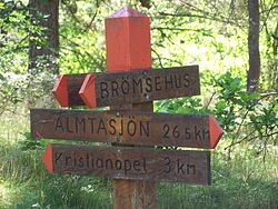
 Signpost on the Blekingeleden |
|
| Data | |
| length | 240 km |
| Starting point |
Sölvesborg 56 ° 3 '28.8 " N , 14 ° 33' 6.5" E |
| Target point |
Kristianopel 56 ° 15 ′ 20.4 " N , 16 ° 2 ′ 38" E |
Blekingeleden is a long distance hiking trail through the Swedish province of Blekinge .
The Blekingeleden extends over a length of about 240 kilometers from Sölvesborg to Kristianopel . It mainly runs through forests and nature reserves such as the Ryssberget beech forest area . The hiking trail also runs along the Mörrumsån river .
The Blekingeleden (led = path) consists of 15 official sections with lengths between 11 and 29 kilometers. Between Sölvesborg and Boafall it briefly shares the route with the Skåneleden . There are a total of five refuges on the way .
literature
- Niklas Kämpargård: Vandra Blekingeleden . Calazo, 2019, ISBN 978-91-88779-53-3 (Swedish).
- Rüdiger Lohf: Sweden: Skaneleden and Blekingeleden (= outdoor manual: The path is the goal . No. 89 ). 2002, ISBN 3-89392-189-3 .
Web links
Commons : Blekingeleden - Collection of Images