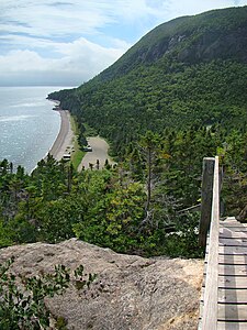
Blow Me Down Provincial Park
|
Blow Me Down Provincial Park
|
||
|
On the south bank of the Humber Arm |
||
| location | Newfoundland and Labrador , Canada | |
| WDPA ID | 19338 | |
| Geographical location | 49 ° 6 ' N , 58 ° 22' W | |
|
|
||
| Setup date | 1975 | |
| administration | Government of Newfoundland and Labrador, Department of Tourism, Culture, Industry and Innovation | |
The Blow Me Down Provincial Park (literally translated as "Woe-me-down" - because of the often windy weather, it could also mean: "I think a horse is kicking me!") Is a Newfoundland provincial park ( Newfoundland and Labrador , Canada ) in the west of the island of Newfoundland on the coast of the Gulf of St. Lawrence about 60 km west of Corner Brook .
The provincial park is located on a small mountainous peninsula about 2 km long on the southwest coast of the Bay of Islands . The peninsula lies between the two bays Lark Harbor in the west and York Harbor in the east. The Highway 450 leads from Corner Brook along the south coast of the Bay of Islands for Blow Me Down Provincial Park. The mountains of the peninsula consist of 450 million years old rock and reach a height of 250 m in Murry Mountain .
The provincial park offers a campsite and hiking trails within the park area.

