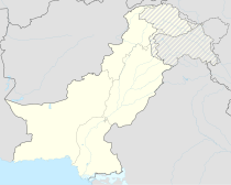
Bolan dam
Coordinates: 29 ° 15 ′ 11 " N , 67 ° 35 ′ 26" E
The Bolan Dam (Nari Bolan Dam) is a dam in Pakistan, Balochistan Province , Kacchi Plain. It was built around 1960 and was used for irrigation. The dam on the Bolan River, made of earth and rock debris, was 19 m high (according to Rehman even 41 m (135 feet)), 530 m long and the storage volume was 89 million cubic meters. The catchment area covers 5000 km².
Nearby places are Ziarat, Dera Bugti and Loralai. The provincial capital of Quetta is located at a greater distance in the northwest (120 km) .
The dam was flooded in a storm in September 1976 and destroyed because the locks on the flood relief could not be opened. There was a tidal wave in which between 20 and 24 people drowned. Damage was also caused to fields, animals, roads and other property in the Bolan Valley.
From 1988 the dam should be rebuilt.
Individual evidence
- ↑ a b SAFETY OF SO-CALLED SMALL DAMS IN PAKISTAN by Altaf ur Rehman (PDF; 2.7 MB)
See also
Web links and literature
- SAFETY OF SO-CALLED SMALL DAMS IN PAKISTAN by Altaf ur Rehman (PDF; 2.7 MB)
- Dams and Disease: Ecological Design and Health Impacts of Large Dams, Canals and Irrigation Systems by William Jobin, 1999
- ICOLD Bulletin 109, Appendix 1, Classification of Reported Failures (excl. China & USSR)
