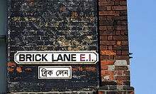
Brick Lane
The Brick Lane ( Bengali : ব্রিক লেন) is a street in the London borough of Tower Hamlets . It runs from Bethnal Green in the north through Spitalfields to Whitechapel in the south and is one of the most famous streets in the East End of London . The street is considered to be the heart of the Bangladeshi community in London and is known for its numerous South Asian restaurants and street market, among other things. The street and street market are now considered a London tourist attraction.
The Brick Lane is approximately one kilometer long and mostly only passable in one direction.
history

The street was originally named Whitechapel Lane and ran in a rural area. Its current name refers to the brick production that has been processing the local brick clay since the 15th century. In the 17th century the street developed into a residential area due to the increase in population. Numerous immigrants settled in the area, initially French Huguenots . During this time, the district developed into a center for weaving, tailoring and clothing manufacturing.
In the 19th century, an increasing number of Irish immigrants and Ashkenazi Jews settled on Brick Lane. At the beginning of the 20th century, the number of Jews increased due to a new wave of immigration. In the late 20th century, a new group of immigrants from Bangladesh joined and now dominates and shapes the street.
In 1742 the Huguenots built La Neuve Eglise , a Protestant church, on the corner of Brick Lane and Fournier Street. From 1809 it was used by missionaries as The Jews' Chapel for proselytizing the growing Jewish population. From 1819 on, it served the Methodist community as a church, and from 1898 it was a synagogue under the name Machzikei HaDath . After the arrival of numerous Bangladeshis, it has served as a mosque since 1976 under the name London Jamme Masjid . The building is under monument protection (Grade II * listed).
Web links
- Website
- Brick Lane entry at the Survey of London (1957)
- Virtual e-Tour Brick Lane Shockwave Player required
- Our Brick Lane - Eastside Community Heritage
Individual evidence
- ↑ BBC: Bangladeshi London
- ↑ expedia.de: Brick Lane ( Memento of the original from July 27, 2014 in the Internet Archive ) Info: The archive link was inserted automatically and has not yet been checked. Please check the original and archive link according to the instructions and then remove this notice.
- ↑ timeout.com: Brick Lane Market Guide
- ↑ tripadvisor: Brick Lane
- ↑ london-kurztrip.de: Brick Lane ( Memento of the original from July 7, 2014 in the Internet Archive ) Info: The archive link was automatically inserted and not yet checked. Please check the original and archive link according to the instructions and then remove this notice.
- ↑ Brick Lane Tourist Guide ( Memento of the original from July 28, 2014 in the Internet Archive ) Info: The archive link was inserted automatically and has not yet been checked. Please check the original and archive link according to the instructions and then remove this notice.
- ^ "Stepney: Economic History", A History of the County of Middlesex: Volume 11: Stepney, Bethnal Green (1998), pp. 52-63 Retrieved October 15, 2007.
- ^ "Bethnal Green: The West: Shoreditch Side, Spitalfields, and the Nichol", A History of the County of Middlesex: Volume 11: Stepney, Bethnal Green (1998), pp. 103-109 Retrieved October 15, 2007.
- ^ "Bethnal Green: Settlement and Building to 1836", A History of the County of Middlesex: Volume 11: Stepney, Bethnal Green (1998), pp. 91-5 Data retrieved April 17, 2007
- ↑ John A. Jackson, Irish in Britain , 137-9, 150 (Routledge & Kegan Paul, 1964)
- ^ The Jews , A History of the County of Middlesex: Volume 1: Physique, Archeology, Domesday, Ecclesiastical Organization, The Jews, Religious Houses, Education of Working Classes to 1870, Private Education from Sixteenth Century (1969), pp. 149-51
- ^ The Spatial Form of Bangladeshi Community in London's East End Iza Aftab (UCL) (particularly background of Bangladeshi immigration to the East End). Data accessed April 17, 2007
- ^ Lucy Dixon, "A brief history of the Mosque" ( Memento October 7, 2008 on the Internet Archive ), My Tower Hamlets website, accessed October 15, 2007
- ↑ Images of England ( Memento of the original from October 29, 2014 in the Internet Archive ) Info: The archive link was inserted automatically and has not yet been checked. Please check the original and archive link according to the instructions and then remove this notice.
Coordinates: 51 ° 31 ′ 19.2 " N , 0 ° 4 ′ 18" W.

