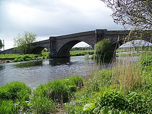
Bridge of Dun
Coordinates: 56 ° 42'59 " N , 2 ° 33'9" W.
| Bridge of Dun | ||
|---|---|---|
| Bridge of Dun | ||
| use | Road bridge | |
| Convicted | Back road | |
| Subjugated | South Esk | |
| place | near Farnell | |
| construction | Stone arch bridge | |
| width | 5.5 m | |
| Number of openings | 3 | |
| Clear width | 15.2-20.7 m | |
| start of building | June 7, 1785 | |
| completion | January 27, 1787 | |
| planner | Alexander Stevens | |
| location | ||
|
|
||
The Bridge of Dun is a road bridge near the Scottish town of Farnell in the Council Area Angus . In 1971 the bridge was included in the Scottish Monument List in the highest monument category A. A former additional classification as a Scheduled Monument was lifted in 1999. The Bridge of Dun station, named after the bridge, is located around 250 m to the northeast.
The foundation stone of the Bridge of Dun planned by Alexander Stevens was laid on June 7, 1785. Construction was completed on January 27, 1787. The contracted construction cost was £ 3,128.
description
The masonry viaduct spans the South Esk around 4.5 kilometers northeast of Farnell near its confluence with the Montrose Basin . It leads a side street of little infrastructural importance with three bricked segment arches over the river. The central arch has a clear width of 20.7 m, while the flanking arches have a clear width of 15.2 m each. Above the icebreaker there are pillars that support the outlets along the parapet of the 5.5 m wide bridge. The bricked-in accesses are made with flood arches leading over land. Small obelisks on the parapet mark the beginning of the bridge.
Individual evidence
- ↑ a b Listed Building - Entry . In: Historic Scotland .
- ↑ a b Entry on Bridge of Dun in Canmore, the database of Historic Environment Scotland (English)
Web links
- Entry on Bridge of Dun in Canmore, Historic Environment Scotland database

