
South Esk (North Sea)
| South Esk | ||
 |
||
| Data | ||
| location | Angus , Scotland | |
| source | in the Grampians 56 ° 55 ′ 38 " N , 3 ° 16 ′ 56" W. |
|
| Source height | 960 m ASL | |
| muzzle | at Montrose in the North Sea coordinates: 56 ° 42 ′ 10 ″ N , 2 ° 27 ′ 12 ″ W 56 ° 42 ′ 10 ″ N , 2 ° 27 ′ 12 ″ W |
|
| Mouth height | 0 m ASL | |
| Height difference | 960 m | |
| Bottom slope | 12 ‰ | |
| length | 79 km | |
| Flowing lakes | Montrose Basin | |
The South Esk is a river in the Scottish Council Area Angus . It rises 960 m above sea level on the slopes of the Grampians .
About the first half of its 79 km long run runs in a south-easterly direction. At about Kirriemuir , which the South Esk passes four kilometers to the north, the flow turns to the east. It passes Forfar five kilometers north, is crossed by the A90 and reaches Brechin . At Montrose , six kilometers east of Brechin, the South Esk widens to the Montrose Basin . Leaving this below the bridge of the A92 in an easterly direction, it flows one kilometer further into the North Sea . About five kilometers north is the mouth of the North Esk , which forms the border between Angus and Aberdeenshire . The South Esk takes on numerous streams on its course. The Noran Water is one of its main tributaries .
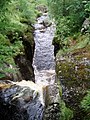
Upper course of the South Esk

Mouth of the South Esk


Web links
Individual evidence
- ↑ a b Esk, South. In: Francis H. Groome: Ordnance Gazetteer of Scotland: A Survey of Scottish Topography, Statistical, Biographical and Historical. Volume 3: (Edr - Har). Thomas C. Jack, Grange Publishing Works, Edinburgh et al. 1885, p. 578.
- ^ A b South Esk, River. In: David Munro, Bruce Gittings: Scotland. An Encyclopedia of Places & Landscapes. Collins et al., Glasgow 2006, ISBN 0-00-472466-6 .
- ^ North Esk, River (North Water). In: David Munro, Bruce Gittings: Scotland. An Encyclopedia of Places & Landscapes. Collins et al., Glasgow 2006, ISBN 0-00-472466-6 .