
Aberdeenshire
|
Aberdeenshire Siorrachd Obar Dheathain |
|
|---|---|
  |
|
| Administrative headquarters | Aberdeen |
| surface | 6,313 km² (4.) |
| Population (2012) | 252,973 (6.) |
| ISO 3166-2 | GB-ABD |
| ONS code | 00QB |
| Website | www.aberdeenshire.gov.uk |
| Aberdeenshire (traditional) | |

|
|
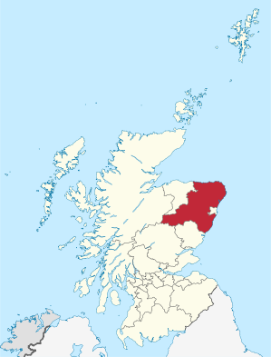
Aberdeenshire ( Gaelic Siorrachd Obar Dheathain ) has been one of 32 Council Areas in Scotland since 1996 . The area comprises the hinterland of the city of Aberdeen and is essentially bordered by Moray in the north-west and Angus in the south, shares a brief border with Perth and Kinross and Highland in the west and is enclave with the city of Aberdeen . From 1975 to 1996 the area belonged to the Grampian region and during that time it was divided into the districts of Banff and Buchan , Gordon and Kincardine and Deeside .
Aberdeenshire is also one of the traditional counties of Scotland and as such includes the city of Aberdeen. From 1889 to 1975 Aberdeenshire also existed as an administrative county , which essentially bordered Banffshire in the north-west and Angus and Kincardineshire in the south-east, and shared a brief border with Inverness-shire and Perthshire in the west; the city of Aberdeen was not part of the administrative county even then as the "County of City". Aberdeenshire is now also one of the Lieutenancy Areas of Scotland.

geography
The traditional county was divided into five landscapes in the popular view:
- Mar , which lies mostly between the Dee and Don Rivers and occupies almost the entire southern half of the county and (as a landscape) also includes the city of Aberdeen. Mar is mountainous, especially Braemar , which contains most of the mountainous land in the British Isles . The valley of the Dee has sandy soil, the valley of the Don is loamy.
- Formartine, located on a sandy coast between the lower Don and Ythan, has clayey, fertile built-up areas in the coastal country, which are further interrupted in the interior by low hills, heather and moor.
- Buchan is the second largest landscape, is north of Ythan and encompasses the northeast of the county; Parts of the coast are rocky and wild, the inland is bare, low and flat, partly wavy and peaty. On the coast, 10 kilometers south of Peterhead, are the "Bullers of Buchan" - a basin in which the sea, entering through a natural arch, boils up violently in stormy weather. "Buchan Ness" is the easternmost point of Scotland.
- The Garioch, as pronounced "the geeree" in English, is a beautiful, wavy, loamy and fertile valley that used to be called the granary of Aberdeen.
- Strathbogie, a considerable area south of the Deveron, consists mostly of hills, heather and bog.
The mountains are the most formidable part of the county. Ben Macdhui (1309 m), a great mass, the second highest mountain in Great Britain , Braeriach (1296 m), Cairn Toul (1291 m), Beinn a 'Bhùird (1197 m), Ben Avon (1171 m), the "dark" Lochnagar (1155 m) from the famous poem by Lord Byron , An Sgarsoch (1047 m) and Culardoch (900 m) are the most important peaks in Mar. Further north, the Buck of Cabrach (722 m) rises on the border with Banffshire, the Hillfort on the Tap o 'Noth (563 m), the Bennachie (526 m), the tip of which can be seen from many places in the northeast of the country, and the John Imlah (* 1799 in Aberdeen; † 1846 in Jamaica ) the song O gin I was dedicated to faur the Gadie rins ( O gin I were where the Gadie (tributary of the Don) rins ), and the Foudland (466).
The most important rivers are the Dee (145 kilometers long), the Iyon (132), the Ythan (60) with mussel beds at the mouth, the Ugie (32) and the Deveron (100), which is partly on the border with Banffshire. Salmon and trout are abundant in the rivers, pearl oysters are found in Ythan and Don - a valuable pearl in the Scottish crown is said to come from the Ythan. Loch Muick , the largest of the county's few lakes, 399 meters above sea level, is 2.5 km long and 500 to 800 meters wide, is about 14 kilometers southwest of Ballater and has Glas-allt Shiel, a royal hunting lodge, on its southwest end. Loch Strathbeg, ten kilometers southeast of Fraserburgh, is only separated from the sea by a narrow piece of land. There are ferrous springs in Peterhead, Fraserburgh and Pannanich near Ballater.
geology
Most of the land is made up of crystalline shale that is part of the metamorphic rock of the Eastern Highlands. On the upper reaches of the Dee and Don they form clearly visible groups of which the most common types are (1) black slate and phyllite with calcflinta and a thin band of amphibolic limestone , (2) Blair-Atholl limestone, and (3) quartzite . These sections are folded in steeply sloping to vertical axes with northeast-southwest directions that are repeated over a considerable area. The quartzite is usually present as the top layer. There are notable spots that show this stratification in Glen Clunie and its side valleys above Braemar.
East down the Dee and Don and north over the plain from Buchan towards Rattray Head and Fraserburgh one finds biotite - gneiss , partly from sediments and maybe partly from igneous rock . A slate belt, which was quarried for the roofing, stretches along the western border of the county from Turriff via Auchterless and the Foudland Hills to Tap o'Noth near Gartly. Eruptive material penetrated the metamorphic rock, some of it before, but most of it after the layers were folded. The main types of the former are represented by swellings of epidiorite and hornblende gneiss in Glen Muick and Glen Callater, which have been penetrated by multiply folded granite and pegmatite in passages and lenses.
The later granites, which follow the folding of the slate, are widely distributed in the area of Ben Macdhui and Ben Avon and on Lochnagar; they extend eastward from Ballater via Tarland to Aberdeen and northward to Bennachie. Isolated masses occur at Peterhead and Strokes. Although mostly consisting of biotite granite, the later faults pass intermediate steps made of diorite , such as in the area between Balmoral and Gairn . The granites have been mined extensively in Rubislaw, Peterhead and Kemnay. Serpentine and troctolite , the exact age of which is unknown, appear at Black Dog Rock near Aberdeen, Belhelvie and Oldmeldrum . Where the slates of sedimentary origin were punctured by these eruptive faults, they are mixed with contact minerals such as sillimanite , cordierite , cyanite and andalusite . There are cordierite rocks at Ellon , at the foot of Bennachie, and on the summit of Buck of Cahrach. With ribbons and sprinkling-provided Calcium - Silicate - Hornfels which the limestone in Iverry If, west northwestern Braemar occurs, has Malakolit generated wollastonite (Tafelspat), brown Idocrase (Vesuvianite), garnet , sphene and hornblende. A larger selection of minerals has been extracted from a limestone exposure and associated deposits at Glen Gairn, approximately six kilometers above where the river meets the Dee.
Narrow belts of red sandstone lying on the old slate have been traced from the north coast at Peterhead to Turriff to Fyvie, as well as from Huntly to Gartly to Kildrummy Castle . The layers consist mainly of conglomerates and sandstone, which - in Gartly and Rhyme - are interspersed with lenticular bands of andesite , and thus at least at times indicate volcanic activity. Small deposits of conglomerate and sandstone from this period have been found during excavations in Aberdeen.
The ice age deposits, especially in the belt on the coast between Aberdeen and Peterhead, provide important evidence. The ice moved eastward from the upper reaches of the Dee and Don, while the mass spreading from the Moray Firth penetrated the low plateau of Buchan, but at times also ran significantly northward, parallel to the coast, as the camp of red clay north of Aberdeen shows . At a later time, the local glaciers deposited material on this red clay. A committee set up by the British Association has shown that the Greensand, which produced a large series of Cretaceous fossils in Moreseat in the parish of Cruden, occurs in glacial drift and is believed to have stopped on granite. The stratum from which the Moreseat fossils were taken were not found in this part of Scotland until then, but Jukes Brown observed that the horizon of the fossils is that of the Isle of Wight's lower Greensand or the Aptia stratum in France . Chalk flint is widely dispersed in the drift between Fyvie and the east coast of Buchan. In Plaidy there is a patch of clay with fossils from the Lias . A bed of diatomite was found under the peat at various locations between Logie Coldstone and Dinnet .
Flora and fauna
The peaks of the highest mountains have arctic flora. At the royal house on Loch Muick , 411 m above sea level. NN grow larch trees , vegetables, currants , laurels , roses etc. Some ash trees with a circumference of 1 to 1.5 meters up to 400 meters. Trees, especially Scots pine and larch, grow well here, and Braemar has plenty of its own timber. Pine and oak stumps found in peat sometimes far exceed today's sizes.
There are moles up to 550 meters, squirrels up to 450 meters. Chicken birds such as partridges and hares are abundant, and rabbits are often in abundance. Deer are particularly common in Braemar, which has the largest deer forest in Scotland.
-Gro%C3%9Fbritannien.png)
climate
With the exception of the mountainous regions, Aberdeenshire has a comparatively mild climate thanks to the proximity of large parts of the county to the sea. The mean annual temperature in Braemar reaches 6 ° C, in Aberdeen 8 ° C. The mean annual rainfall varies between 750 and 950 mm. In summer, the upper valleys of Dee and Don promise the driest, bracing climate in the British Isles, grain can be grown here up to 500 meters, 100 to 150 meters more than in the rest of Britain.
Prehistory and History
Scotland was covered by glaciers during the Ice Age. Between about 8000 and 7500 BC The hunters reached this zone. From 4500 they were followed by the arable farmers. Megalithic sites are not available, but the area is filled with Henges , Hillforts ( Dunnideer , Tap o 'Noth ), stone circles ( Cullerlie , Easter Aquhorthies , Nine Stanes , Loanhead of Daviot , Midmar , Old Keig, Sunhoney , Strichen ) and basement ( Culsh ). A specific type of ancient stone circle (the Recumbent Stone Circles ) is more common here than anywhere else in the British Isles. Relics of the past are also the long "earthern Long Barrows" (Catto 48 m, Capo 80 m, Gourdon 90 m and Longman Hill 67 m) and the Cairns Cairn of Memsie and the one on Tullos Hill . Also menhirs (Broomend of Crichie) and some Piktensteine ( Kintore , Maiden Stone, Rhynie ) are available here. There are also sculptures and cross-slabs from the early Christian era.
Souterrains or earth houses (schott. "Weems") can be found mainly on the Don and Dee rivers. Remnants of Crannógs at Loch Ceander, in southern Loch Kinnord, near Dinnet, and at Loch Goul in the municipality of New Machar. The usual brochures in the north are not available here, but hillforts can be found on the hill (Barra near Oldmeldrum).
The landscape that later formed the counties of Aberdeenshire and Banffshire was the home of the northern Picts , whom Ptolemy called Taixall , whose land was Taixalon . Their town of Devana, believed to be identical to present-day Aberdeen, was identified by John Stewart with a site in the parish of Peterculter , where remains of old camps in Normandy have been found. William Forbes Skene locates Devana with a course on Loch Davan, west of Aboyne. Alleged Roman camp was discovered at the upper Ythan and Deveron. However, there is no evidence of an actual Roman presence there. Efforts to convert the Picts began with Teman in the 5th century and were continued by Columban of Iona (who founded Deer Monastery in Old Deer ), but lasting results were slow to show. Indeed, disagreement within the Church of Columban and the expulsion of clerics from the land of the Picts by King Nectan in the eighth century destroyed most of the work of missionaries. The Vikings and Danes haunted the coast, but after Macbeth ascended the Scottish throne in 1040 , the Vikings, under the direction of Thorfinn, refrained from further bothering the northeast of Scotland. Macbeth was slain in Lumphanan in 1057 AD, a cairn on Perkhill commemorates this.
The influence of the Norman conquest of England was felt even in Aberdeenshire. Along with many Anglo-Saxon exiles, Flemings settled in the county who brought various crafts with them, Saxons with their agriculture, and Scandinavians with their nautical knowledge. The Celts revolted more than once, but Malcolm Canmore and his successors oppressed them and confiscated their land. Under Alexander I , who ruled from 1107 to 1124, Aberdeen is mentioned for the first time, originally called Abordon (Abor Dun) and in the Viking sagas Apardion, and which received its charter from William the Lion in 1179; By then the citizens had already joined forces with those of Banff, Elgin, Inverness, and other communities beyond the Grampians in a free Hanseatic League , under whose flag they enjoyed remarkable privileges. At that time, in 1150, the church had expanded its organization to such an extent that a bishopric could be established in Aberdeen.
In the 12th and 13th centuries, some of the county's large families appeared, including the Earls of Mar (ca 1122), the Leslies, Freskins (ancestors of the Dukes of Sutherland ), Durwards, Bysets, Comyns, and Cheynes - most of whom, significantly, immigrated were.
The Celtic Thane and their people were slow to mingle with the settlers. Refusing to take advantage of the troubled situation during the Scottish War of Independence, they made common cause with the bulk of the people.
Although John Comyn († 1302), one of the aspirants to the Scottish throne , had significant interest in the county, his claim received little support. In 1296 the English King Edward I managed a triumphant campaign to the north, where he terrorized the more stormy nobles. The following year, William Wallace surprised the English garrison in Aberdeen, but failed to capture the castle. In 1303 Eduard returned to the country, besieging the castle of Kildrummy, which at the time was owned by Robert the Bruce , who a short time later became the recognized leader of the Scots and made Aberdeen his headquarters for several months . Despite the seizure of Kildrummy Castle by the English in 1306, Bruce's prospects increased from 1308 when he defeated John Comyn, Earl of Buchan , († 1308) in Inverurie.
Anarchy ruled the county for a hundred years after Robert Bruce's death (1329). The English burned Aberdeen in 1336, and the repopulation of Buchan and Strathbogie districts resulted in permanent feuds with the dispossessed. In addition, the crown was involved in battles with some highland chiefs who were about to lose their independence. This policy culminated in the invasion of Aberdeenshire by Donald, Lord of the Isles , who was defeated by the Earl of Mar at the Battle of Harlaw at Inverurie in 1411.
In the 15th century, two other leading families in the country came to power: Sir Alexander Forbes , who became Lord Forbes in 1442, and Sir Alexander Seton, Lord Gordon from 1437 and Earl of Huntly from 1445. For a long time bitter feuds were fought between these families, and the Gordons reached the height of their power in the first half of the 16th century, when their holdings, already tremendously, were expanded to include Sutherland by marriage in 1514.
In the meantime, trade with the Netherlands , Poland and the Baltic States had grown significantly, and Campvere ( Veere in Dutch ) near Flushing ( Vlissingen ) became the branch of the Scottish traders. The establishment of King's College in Aberdeen in 1497 (Marischal College followed a hundred years later) encouraged education. At the time of the Reformation , the clergy got so little idea of the development that the building and decoration of the churches in the county continued, while the religious structures in the south were already destroyed. Protestantism reached the county without much turmoil, although there were riots in Aberdeen and damage to St Marchar's Cathedral in the city. The 4th Earl of Huntly offered some resistance to Lord James Stuart on behalf of the Catholics , but was defeated and killed in the Corrichie on Fare Hill in 1562.
Over time it turned out that the Presbyterians were less popular than the episcopal church, whose stronghold in Scotland Aberdeenshire remained for generations.
Another religious crisis occurred in 1638, when the authorities demanded a subscription to the National Covenant ("Solemn League and Covenant"). Aberdeenshire's response was such that James Graham, 1st Marquess of Montrose, went to the county the following year to seek recognition. The knighthood, unwilling to give in, dispersed an army raised by the Covenantern in a meeting called the "Trot of Turriff" (1639), shedding the first blood of the civil war. The Covenanters gained the upper hand a few weeks later when Montrose appeared at the Dee Bridge and forced the submission of Aberdeen, which had no choice and had to submit to its lot.
Montrose, however, soon switched sides and surrendered the city to sack after defeating the Covenanters under Lord Balfour of Burleigh in 1644. He defeated the Covenanters again in a relentless battle on July 2, 1645 in Alford. Peace was restored through the intervention of Scottish plenipotentiaries on behalf of King Charles I.
Aberdeen greeted Charles II on his return from the Netherlands in 1650, but a little over a year later, General George Monck entered the city at the head of one of Cromwell's regiments. The English garrison remained until 1659, but the following year Aberdeen gushed at the Restoration . Most Presbyterians conformed, while the Quakers (Religious Society of Friends), who were more numerous in the county and neighboring County Kincardine than elsewhere in Scotland, suffered systematic persecution.
After the Glorious Revolution of 1688 the skies became cloudy for the episcopal church, but the clergy, yielding to the force majeure , gradually accepted the inevitable in the hope, as long as Anne lived, that it would again become the official form of church regiment. Her death shattered those dreams, and since George I , her successor, disliked the clergy, the Jacobites and episcopalism were considered equal in the county, even though in fact the oathers as a community did not support the rebellion.
The Earl of Mar rose at Braemar on September 6, 1715; Fourteen days later, James Francis Edward Stuart was proclaimed in Aberdeen; the applicant for the throne ("Pretender") landed in Peterhead on December 22nd, but in February 1716 he was back in France. The collapse of that first uprising ruined many of the landlords, and when the second rebellion began thirty years later, the county remains essentially indifferent, though the insurgents ruled Aberdeen for five months and Lord Lewis Gordon at Inverurie on December 23, 1745 won an insignificant victory over Prince Charles Edward Stuart ("Bonnie Prince Charlie"). Wilhelm August, Duke of Cumberland , liberated Aberdeen at the end of February 1746, and in April the "Young Pretender" was on the run.
After these events, the people of Aberdeenshire were able to return to their normal chores, agriculture, handicrafts and commerce which, together with advances in education, developed so remarkably well that the county became one of the wealthiest in Scotland.
places
Attractions
Castles and Palaces
- Balmoral Castle
- Castle Fraser
- Dunnideer , Hillfort and castle ruins
- Dunnottar Castle
- Findlater Castle
- Fyvie Castle
- Kildrummy Castle
More Attractions
- Scotland's Lighthouse Museum
- Stone circles ( Cullerlie , Easter Aquhorthies , Loanhead of Daviot , Midmar , Nine Stanes and Sunhoney etc.)
- the settlement of New and Old Kinord and Tullos Hill
politics
Aberdeenshire is divided into 19 constituencies ( wards ), each with three or four seats. The Aberdeenshire Council has 70 seats, split among the parties following the 2017 local elections as follows:
| Political party | Seats | +/− to 2011 |
|---|---|---|
| Scottish Conservatives | 23 | +9 |
| Scottish National Party | 21st | −7 |
| Liberal Democrats | 14th | +2 |
| Independently | 10 | −1 |
| Labor | 1 | −1 |
| Scottish Greens | 1 | ± 0 |
Web links
Individual evidence
- ↑ 2011 census
- ↑ z. B. Loch Kinord Cross Slab
- ↑ Aberdeenshire Council ( Memento of the original of July 2, 2017 in the Internet Archive ) Info: The archive link was automatically inserted and has not yet been checked. Please check the original and archive link according to the instructions and then remove this notice. (Accessed July 8, 2017)
Aberdeen | Aberdeenshire | Angus | Argyll and Bute | Clackmannanshire | Dumfries and Galloway | Dundee | East Ayrshire | East Dunbartonshire | East Lothian | East Renfrewshire | Edinburgh | Falkirk | Fife | Glasgow | Highland | Inverclyde | Midlothian | Moray | Outer Hebrides | North Ayrshire | North Lanarkshire | Orkney | Perth and Kinross | Renfrewshire | Scottish Borders | Shetland | South Ayrshire | South Lanarkshire | Stirling | West Dunbartonshire | West Lothian
Aberdeenshire | Angus | Argyll | Ayrshire | Banffshire | Berwickshire | Bute | Caithness | Clackmannanshire | Cromartyshire | Dumfriesshire | Dunbartonshire | East Lothian | Fife | Inverness-shire | Lanarkshire | Kincardineshire | Kinross-shire | Kirkcudbrightshire | Midlothian | Morayshire | Nairnshire | Orkney | Peeblesshire | Perthshire | Renfrewshire | Ross-shire | Roxburghshire | Selkirkshire | Shetland | Stirlingshire | Sutherland | West Lothian | Wigtownshire