
Argyll and Bute
| Argyll and Bute Earra-Ghàidheal agus Bòd |
|
|---|---|
  |
|
| Administrative headquarters | Lochgilphead |
| surface | 6,909 km² (2.) |
| Residents | 88,166 (26.) |
| ISO 3166-2 | GB GTC |
| ONS code | 00QD |
| Website | www.argyll-bute.gov.uk |
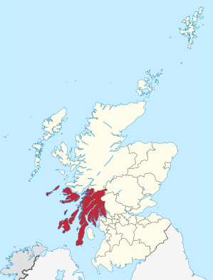
Argyll and Bute ( Gaelic : Earra-Ghàidheal agus Bòd ) is one of 32 Council Areas in Scotland . It borders Highland , Perth and Kinross , Stirling and West Dunbartonshire . The eastern border runs through Loch Lomond . The administrative headquarters are in Lochgilphead .
Most of the county was once part of traditional Argyll County , with the exception of Morvern, north of Mull , which is now part of the Highland. The district also includes the Isle of Bute in the Firth of Clyde , which was part of the traditional county of Bute , and the western part of the traditional county of Dunbartonshire .
places
Attractions
- Argyll Forest Park
- Caisteal Suidhe Cheannaidh a well-preserved dun
- Carrick Castle
- Cruachan Dam
- Fincharn Castle
- Fingal's Cave
- Gare hole
- Kilchurn Castle
- Lachlan Castle
- Loch Lomond
- Old Lachlan Castle
- Strontoiller
- Younger Botanic Garden
See also List of Category A structures in Argyll and Bute
Islands
politics
As of the 2017 local elections, the 36-seat council of Argyll and Bute has been composed as follows:
| Political party | Seats |
|---|---|
| Scottish National Party | 11 |
| Independently | 10 |
| Liberal Democrats | 9 |
| Scottish Conservatives | 6th |
partnership
A partnership with the Amberg-Sulzbach district in Bavaria has existed since 1967 .
Individual evidence
- ↑ 2011 census
- ↑ Argyll and Bute Council: 2017 Election Results (accessed July 8, 2017)
Web links
Aberdeen | Aberdeenshire | Angus | Argyll and Bute | Clackmannanshire | Dumfries and Galloway | Dundee | East Ayrshire | East Dunbartonshire | East Lothian | East Renfrewshire | Edinburgh | Falkirk | Fife | Glasgow | Highland | Inverclyde | Midlothian | Moray | Outer Hebrides | North Ayrshire | North Lanarkshire | Orkney | Perth and Kinross | Renfrewshire | Scottish Borders | Shetland | South Ayrshire | South Lanarkshire | Stirling | West Dunbartonshire | West Lothian
Coordinates: 56 ° 10 ′ N , 5 ° 31 ′ W