Luing
| Luing | |
|---|---|
| Road to Cullipool | |
| Waters | Atlantic Ocean |
| Archipelago | Slate Islands , Inner Hebrides |
| Geographical location | 56 ° 13 '53 " N , 5 ° 38' 32" W |
| surface | 14.3 km² |
| Residents | 195 (2007) 14 inhabitants / km² |
| main place | Cullipool |
Luing ( Scottish Gaelic : An t-Eilean Luinn ) is one of the Slate Islands ( German "Schieferinseln" ). It is located in Lorne off the west coast of Argyll and Bute in Scotland , about 16 miles south of Oban . It belongs to the Inner Hebrides .
The island had about 195 residents in 2011. Most live in the towns of Cullipool , Toberonochy (Scottish Gaelic: Tobar Dhonnchaidh ) and Black Mill Bay .
There is a ferry connection between the island and the town of Cuan on the island of Seil .
The islanders live mainly from tourism , lobster fishing and cattle farming . Slate breaking played an important role until 1939 . There were two large quarries at Toberonochy and Cullipool and a smaller one at Port Mary. For example, Luing slate was used in the construction of the University of Glasgow .
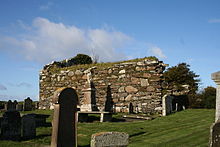
To the south are the ruins of Kilchatton Chapel. At Toberonochy lies Dun Leccamore , an Iron Age dun .
Despite the small population of the island, three residents of Luing received gold medals at the Scottish song, sports and storytelling festival Mòd :
Individual evidence
Web links
http://www.undiscoveredscotland.co.uk/luing/luing/index.html


