
Sanday (Hebrides)
| Sanday (Sandaigh) | ||
|---|---|---|
_Dun_Mor_1.jpg) |
||
| Waters | Atlantic Ocean | |
| Archipelago | Inner Hebrides | |
| Geographical location | 57 ° 2 '58 " N , 6 ° 29' 39" W | |
|
||
| length | 3 km | |
| surface | 1.8 km² | |
| Highest elevation |
Tallabric 59 m |
|
| Residents | 9 (2011) 5 inhabitants / km² |
|

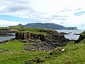
Sanday ( Scottish Gaelic Sandaigh ) is a tidal island in the west of the "Little Islands", which are part of the Scottish Inner Hebrides in the Highlands . It is 3 kilometers long. The island is owned by the National Trust for Scotland .
Sanday is known for its numerous bird species, including the puffin , the great skua and the Atlantic shearling .
The highest point on the island is the Tallabric at 59 meters; it is located in the southwest of Sandy. The neighboring island of Canna is connected to Sanday by a road bridge. In 2018, a road was built on Sanday for the first time that is passable even at high tide. In 2011, nine people lived on Sanday.

Sheep on Sanday

lighthouse
Cnoc Ghreannabric on the north coast

Cave on the south coast

Sandy beach near the road bridge

Former St Edwards Church (now St Edwards Center)

Former school
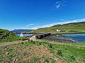
New road bridge from Canna (in the background) to Sanday


.jpg)

_Bridge_2.jpg)
Web links
- 360 ° aerial panorama of Sanday and Canna, in the background Rum (direction of view after loading the panorama is north)
_Aerial_Pan360.jpg)
Individual evidence
- ↑ National Trust for Scotland (2019): 3 key projects (accessed July 13, 2019)
- ↑ Ordnance Survey (2016): OS Landranger map sheet 39 Rùm, Eigg, Muck & Canna. ISBN 978-0-319-26137-8 .
- ↑ BBC (2018): First road built on tiny island of Sanday (accessed July 13, 2019)
- ↑ 2011 census data