Scalpay (Inner Hebrides)
| Scalpay | |
|---|---|
| Looking south from Scalpay to Skye | |
| Waters | Inner Sound ( Atlantic Ocean ) |
| Archipelago | Inner Hebrides |
| Geographical location | 57 ° 18 ′ 7 ″ N , 5 ° 58 ′ 17 ″ W |
| surface | 24.8 km² |
| Highest elevation | Mullach na Càrn 398 m |
| Residents | 4th (2011) <1 inh / km² |
| main place | Scalpay House |
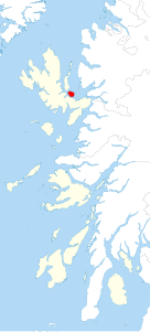
| Location of Scalpay northeast of Skye | |
Scalpay ( Scottish Gaelic : Sgalpaigh , German "Schiffsinsel" ) is a Scottish island that belongs to the Inner Hebrides . It is located near the northeast coast of Skye, northwest of Broadford and south of Raasay Island . The island is 24.8 km². The highest point of Scalpay is the mountain Mullach na Càrn at 398 meters . In 2011 four people lived on Scalpay.
The island is privately owned. There is a deer farm there. The island is mainly characterized by heathland , but was previously also used for forestry. The owner couple and two employees live on the island.
From around 1890 the island belonged to the ship magnate Donald Currie , on whose initiative the first roads were built here and major reforestation measures were carried out.
In Gaelic usage, the island is often called Sgalpaigh an t-Sratha to distinguish it from Sgalpaigh near Harris .
Scalpay, like the smaller islands of Longay and Pabay further east, belongs to the Civil parish Strath , the main part of which is on Skye and to which the town of Broadford also belongs.
Individual evidence
- ↑ 2011 census data
- ^ Scalpay website , accessed May 20, 2012
- ↑ Iain Mac to Tailleir ( Memento of the original from May 29, 2008 in the Internet Archive ) Info: The archive link was inserted automatically and has not yet been checked. Please check the original and archive link according to the instructions and then remove this notice. , "Placenames", p. 103, Pàrlamaid na h-Alba (English)
Web links
- Official website (English)


