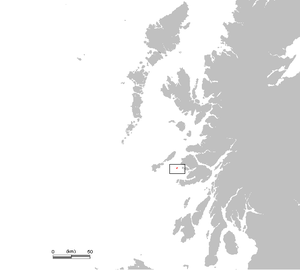
Treshnish Isles
| Treshnish Isles | |
|---|---|
| Treshnish Isles as seen from the Isle of Mull | |
| Waters | Atlantic Ocean |
| archipelago | Inner Hebrides |
| Geographical location | 56 ° 30 ′ N , 6 ° 25 ′ W |
| Number of islands | 8th |
| Main island | Lunga |
| Total land area | 2.4 km² |
| Residents | uninhabited |
| The striking Dutchman's Cap on Bac Mòr | |
The Treshnish Isles are an uninhabited island group that is part of the Inner Hebrides in Scotland .
geography
The archipelago is located in the Atlantic Ocean around 3 km southwest of Port Haunn on the Isle of Mull and 5 km west of Gometra , the neighboring island of Ulva . The Treshnish Isles consist of eight small islands, which together have an area of 2.4 km². They extend over a length of a good 10 kilometers from northeast to southwest. In this order, the following islands and skerries ( Scottish Gaelic : Sgeir ) belong to the archipelago:
- Cairn na Burgh Beag
- Cairn na Burgh Mòr
- Fladda
- Sgeir to Eirionnaich
- Sgeir a 'Chais part
- Lunga with the Dun Cruit (Dùn Cruit)
- Bac Mòr
- Bac Beag
Lunga is the largest island with an area of 0.81 km², followed by Fladda. Lunga is also the highest island, reaching a height of 103 meters in the Cruachan , followed by Bac Mòr, whose former volcanic cone Dutchman’s Cap is 86 meters high.
Flora and fauna
The Treshnish Isles are a refuge for the gray seal ( Halichoerus grypus ) and an important breeding ground for many seabirds , among others for the petrel ( Hydro pelagicus ), the puffin ( Fratercula arctica ) and the Common Murre ( Uria aalge ). The islands are therefore proposed for a Special Protection Area as well as a Special Area of Conservation and for a Site of Special Scientific Interest .
Web links
- Treshnish Isles at the Joint Nature Conservation Committee (English)
- Treshnish Isles on the Argyll Marine SAC website
- Treshnish Isles on the side of Hebridean Trust (English)
Individual evidence
- ↑ Treshnish Isles on southernhebrides.com (English)


