
Sanda Island

Sanda Island ( Scottish Gaelic Sandaigh ) is a 127 acre island near Southend on the southern tip of the Kintyre peninsula in Argyll and Bute in Scotland .
It is known as "Spoon Island" on the Isle of Arran and County Antrim , Northern Ireland , because its profile resembles an upside-down spoon. On clear days, Sanda can be seen from the Kintyre Peninsula, the Isle of Arran, and Northern Ireland.
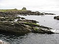
Sanda is in the Strait of Moyle ( Scottish Gaelic Sruth na Maoile ) between Scotland and Ireland . It is part of a mini archipelago at the far end of the Firth of Clyde . The other islands are Glunimore and Sheep Island . The island has cliffs on most of its sides. On the north coast is the Oitir Buidhe (Yellow Sand), a large expanse of sand that is exposed at low tide and has two boat ramps. To the east is the infamous "Paterson's Reef". There are caves on the west coast and a natural arch near the ship, as the lighthouse built in 1850 (with a helicopter platform) is called. Between mountains in the north-west and south-east lies a valley that protects against the prevailing winds.
The Viking name "Sandey" (sand island) probably referred to the Oitir Buidhe, on the north coast. Another name for the island is Havoin (with numerous variants such as "Aven", "Avona"), which Donald Monro (1526–1574) recorded in the 16th century in his "Description of the Western Isles of Scotland". This is related to the English "harbor" and probably refers to the anchorage on the north coast. Due to its importance for migratory and breeding birds, the island is designated as an Area of Special Scientific Interest. The Sanda Bird Observatory was the first bird observatory on the west coast of Scotland. The island of sandstone in red and yellow varieties and slate is treeless, but the name Wood Hill to the northwest suggests that this was not always the case.
Sanda Island has ties to several historical figures including Ninian of Whithorn and the Bruce and Wallace families. On the island are the ruins of a chapel built by St Ninian with a stone cross. It is said that St Ninian is buried here. The island was owned by the Whithorn Priory during the Reformation in 1531 .
- Sanda Island

estate

Oitir Buidhe sandy area

West Coast

View of Sanda - left

Anchorage

St Ninian's Chapel
South coast


In the Middle Ages there were ties to the Bruce clan , particularly Robert the Bruce and his brother Edward. Edward gave the "Prince Edward's Rock" south of the lighthouse his name. Robert was forced to stop there on his way to Ireland. He had sought refuge in Dunaverty Castle in 1306 . According to the heroic poem The Brus, the king stayed with Aonghus Óg Mac Domhnaill for three days before sailing to Rathlin Island via Sanda .
To the south are "Wallace's Rocks", which may be connected to William Wallace . In the late 16th and 17th centuries, the island was associated with the Clan Macdonald of Clanranald . The MacDonalds lost their position as a result of the Dunaverty massacre of 1647. In 2008 the island was put up for sale and in 2009 it was sold. It had no permanent residents at the time of the 2011 census.
literature
- Angus Matheson: Review of Monro's Western Isles of Scotland and Genealogies of the Clans, 1549 by RW Munro ". The Scottish Historical Review. 42 No. 133, Part 1 1963 pp. 48-51. Edinburgh. Edinburgh University Press.
- RW Munro: Monro's Western Isles of Scotland and Genealogies of the Clans. Edinburgh and London. Oliver and Boyd 1961
Web links
Coordinates: 55 ° 17 ′ N , 5 ° 35 ′ W