Isle of Bute
| Isle of Bute | ||
|---|---|---|
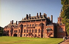
| The Russian tavern in the port of Bannatyne | ||
| Waters | Firth of Clyde | |
| Geographical location | 55 ° 50 ′ N , 5 ° 3 ′ W | |
|
|
||
| length | 24 km | |
| width | 8 kilometers | |
| surface | 122.17 km² | |
| Highest elevation | Windy Hill 273 m |
|
| Residents | 6498 (2011) 53 inhabitants / km² |
|
| main place | Rothesay | |
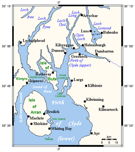
| Map of the Firth of Clyde with the Isle of Bute | ||
Isle of Bute is an island in the Firth of Clyde in south west Scotland . It is located north of the Isle of Arran . Bute was part of the traditional county of Buteshire . Today it is part of the Argyll and Bute Council Area .
geography

Bute is about 24 kilometers long and 8 kilometers wide, and has an area of 122.17 km². It is separated from the Cowal Peninsula by the Kyles of Bute, which is only three hundred meters wide at its narrowest point . The northern part is relatively hilly (highest point: Windy Hill , 273 m) and heavily forested. The much flatter southern part is used for agriculture. There are also a number of lakes here, the three largest of which are Loch Fad , Loch Ascog and Loch Quien . The two parts are separated by the Highland Boundary Fault (about " Highlands boundary fault ").
At the 2011 census, the island had 6,498 inhabitants. The only town is Rothesay with over 4000 inhabitants; the city is roughly in the middle of the east coast. Other localities include Rhubodach , Kilchattan Bay , Kingarth and Port Bannatyne , also on the east coast.
history
In 1703 Queen Anne established the title of Earl of Bute, which was given to a member of a sideline of the Stuart royal dynasty . In 1796 King George III. this to the Marquess of the County of Bute . Today, the former racing driver Sir John Colum Crichton-Stuart also leads those of the 10th Earl of Bute and the 7th Marquess of Bute among his 15 nobility titles .
Economy and Transport
Agriculture and tourism are the main sources of income for the islanders, but forestry and fishing also play a role. Two Caledonian MacBrayne ferry lines connect the island to the mainland:
- Rothesay - Wemyss Bay
- Rhubodach– Colintraive
Attractions
- Rothesay Castle in Rothesay
- Michael's Grave Rest of a Clyde tombs
- Mount Stuart House
- St Blane's Chapel at Kingarth
- Stone circle St Colmac Cottages
- Prehistoric monuments around St. Blane's Chapel:
The rocky headland one kilometer west of St. Blane's Chapel is dominated by the remains of the Dunagoil fortification . The finds from the excavation can be seen in the Bute Museum in Rothesay. Between the Little Dunagoil hill and the main massif is a large stone box that was originally covered by a stone mound . There are also simple graves from the Neolithic period . The earthworks Cnoc An Rath is located near Port Bannatyne .
Web links
- www.isle-of-bute.com (English)
- www.isle-of-bute.org.uk (English)
- Information on undiscoveredscotland.co.uk (English)
Individual evidence
- ↑ Geology of the island at butemuseum.org.uk (English), accessed on October 7, 2015


