
Ugie
| Ugie | ||
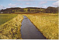
 The Ugie at Peterhead |
||
| Data | ||
| location | Scotland | |
| River system | Ugie | |
| source | Confluence of North and South Ugie Water 57 ° 31 ′ 36 ″ N , 1 ° 54 ′ 29 ″ W |
|
| muzzle | At Peterhead in the North Sea coordinates: 57 ° 31 ′ 1 ″ N , 1 ° 47 ′ 30 ″ W 57 ° 31 ′ 1 ″ N , 1 ° 47 ′ 30 ″ W
|
|
| length | 10 km | |
The Ugie is a river in the Scottish council area of Aberdeenshire . It is created by the confluence of the North and South Ugie Water about two kilometers northeast of Longside . Flowing in an easterly direction, the Ugie flows into the North Sea about ten kilometers north of Peterhead .
The Ugie catchment area measures 335 km 2 and is one of the driest areas in Scotland with a rainfall of 812 mm / year (30-year average). The lowest amounts of precipitation are recorded between February and July. Around 13,000 people live in the rural catchment area. The water from the Ugie is used to supply around 30,000 people in the Peterhead area.

North Ugie Water
South Ugie Water


Web links
Commons : Ugie - collection of images, videos and audio files
Individual evidence
- ^ A b C. Knight (ed.): The English encyclopædia: Geography , Bradbury, Evans & Co., London, 1866, p. 10.
- ^ Entry in the Gazetteer for Scotland
- ↑ a b Study by the Scottish Environment Protection Agency ( page no longer available , search in web archives ) Info: The link was automatically marked as defective. Please check the link according to the instructions and then remove this notice.
- ↑ a b Study by the Scottish Environment Protection Agency ( page no longer available , search in web archives ) Info: The link was automatically marked as defective. Please check the link according to the instructions and then remove this notice.