
Peterculter
| Peterculter | |||
|---|---|---|---|
| Coordinates | 57 ° 6 ′ N , 2 ° 16 ′ W | ||
|
|||
| Residents | 4576 2011 census | ||
| administration | |||
| Post town | PETERCULTER | ||
| ZIP code section | AB14 | ||
| prefix | 01224 | ||
| Part of the country | Scotland | ||
| Council area | Aberdeen | ||
| British Parliament | Aberdeen South | ||
| Scottish Parliament | Aberdeen South and North Kincardine | ||

Peterculter is a suburb of the Scottish city of Aberdeen . It is located about 13 km west of the city center on the north bank of the Dee . The village developed around a mill built in 1751. In 2011 Peterculter had 4576 inhabitants.
traffic
In the 19th century Peterculter got a station on the Deeside Railway line of the Great North of Scotland Railway , which ran from Aberdeen to Ballater . However, the line was closed in 1966. The A93 runs through Peterculter and connects the village to the trunk road network. The A90 runs just a few kilometers east. A road bridge crosses the Dee a few hundred meters to the east.

Peterculter

Milltimber on the right edge of the picture in the middle, behind Peterculter
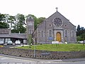
Peterculter Parish Church
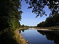
The Dee at Peterculter

The A93 in Peterculter


Eponyms
The Martian crater Culter has been named after the place since 2006.
Individual evidence
- ↑ a b Peterculter. Aberdeen City. In: David Munro, Bruce Gittings: Scotland. An Encyclopedia of Places & Landscapes. Collins et al., Glasgow 2006, ISBN 0-00-472466-6 .
- ↑ 2011 census
- ↑ Peterculter. In: Francis H. Groome: Ordnance Gazetteer of Scotland: A Survey of Scottish Topography, Statistical, Biographical and Historical. Volume 5: (Lib - Pet). Thomas C. Jack, Grange Publishing Works, Edinburgh et al. 1884, p. 200.
- ^ Gazetteer of Planetary Nomenclature