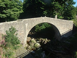
Bridge of Dye
Coordinates: 56 ° 57 ′ 52 " N , 2 ° 34 ′ 32" W.
| Bridge of Dye | ||
|---|---|---|
| Bridge of Dye | ||
| use | Road bridge | |
| Subjugated | Water of Dye | |
| place | near Banchory | |
| construction | Stone arch bridge | |
| Number of openings | 1 | |
| Clear width | 13 m | |
| completion | around 1680 | |
| location | ||
|
|
||
The Bridge of Dye is a former road bridge near the Scottish village of Banchory in the Council Area of Aberdeenshire . In 1972 the bridge was included in the Scottish Monument Lists in the highest monument category A. A former additional classification as a Scheduled Monument was lifted in 2016.
history
There was already a bridge at this location in the late Middle Ages . This was one of the earliest river bridges in northeast Scotland. The current Bridge of Dye was built in 1680 as part of the Edinburgh to Fochabers Military Road . It is the second oldest in the Royal Deeside area . In 1681 a parliamentary resolution introduced a toll for the crossing, from which conclusions can be drawn about the high infrastructural importance of the Bridge of Dye in the sparsely populated hinterland of Aberdeenshire. The Bridge of Dye became obsolete due to the construction of a new bridge only a few meters away, which today leads to the B974.
description
The Bridge of Dye is located around eleven kilometers southwest of Banchory near Mount Shade on the eastern edge of the Grampians . The masonry viaduct spans the Water of Dye , which drains into the North Sea via the Water of Feugh and the Dee , with a lined round arch with four ribs 54 cm apart. Its clear width is 13 meters. A parapet delimits the 3.6 meter wide roadway. The masonry of the Bridge of Dye is made of granite .
Individual evidence
- ↑ a b c Listed Building - Entry . In: Historic Scotland .
- ↑ a b Entry on Bridge of Dye in Canmore, the database of Historic Environment Scotland (English)
Web links
- Entry on Bridge of Dye in Canmore, Historic Environment Scotland database

