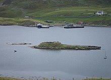
Broch in the West Burra Firth
The Broch in the West Burra Firth (also Broch of West Burrafirth) is an Iron Age Broch on Holm von Hebrista , a small low rock island in a fjord of the Shetland island of Mainland in Scotland . The Nordic name of the fjord was Borgarfjörð, the "fjord of the castle". The name Borgarfiord appears for the first time in a document in Nordic language, dated 1299. The dam that once permanently connected the island and the shore consisted of a row of stones in the manner of a clapper bridge , but is hardly recognizable.
The brochure , which Euan Wallace MacKie believes dates back to the 1st century AD, is in poor condition. The diameter is about 17.5 m and the walls are on average 4.5 m thick. Much of the floor plan can still be seen, but many details are hidden by fallen wall material. The outer surface on the northeast side has collapsed, but there are still eight or nine stone layers in the south.
Access is blocked with stones, but the lintel over the inner end is still there. There seem to have been two guard cells on either side of the entrance. Inside, four wall cells can be seen, two of which are dumbbell-shaped, with short passages between the two halves.
The Archaeological Commission has doubts about a direct connection between the Broch and the Cairn on the bank , as postulated by Euan Wallace MacKie (born 1936).
The brochure is said to have been the home of the Viking Thorbjörn, who lived and was killed here at the time of Hákon Pállsson and Magnús Erlendsson , the Jarls of the Orkney from 1105 to 1115.
literature
- Ian Armit: Towers in the North. The Brochs of Scotland. Tempus, Stroud 2003, ISBN 0-7524-1932-3 , pp. 18-19.
- Ian Armit: Broch Building in Northern Scotland. The context of innovation. In: World Archeology. 21 ( Architectural Innovation ), 1990, 3, ISSN 0043-8243 , pp. 435-445.
Web links
- Entry to Broch in the West Burra Firth in Canmore, Historic Environment Scotland database Map and plan
Coordinates: 60 ° 17 ′ 53.5 " N , 1 ° 32 ′ 17.9" W.
