Broughton Island (New Zealand)
| Broughton Island | ||
|---|---|---|
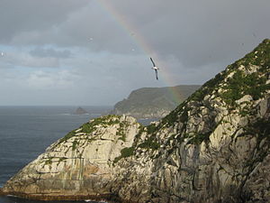
| Broughton Island in the background as seen from North East Island | ||
| Waters | South pacific | |
| Archipelago | Snare Islands | |
| Geographical location | 48 ° 2 ′ 10 ″ S , 166 ° 37 ′ 0 ″ E | |
|
|
||
| length | 1 km | |
| width | 500 m | |
| Highest elevation | (unnamed) 86 m |
|
| Residents | uninhabited | |
| Map of Snares Islands, Broughton Island in the southeast | ||
Broughton Iceland is the second largest island in the archipelago of to New Zealand belonging Snare Islands in the southwestern Pacific Ocean , some 200 km south of the South Island of New Zealand area. The island is named after William Robert Broughton , a British naval officer and explorer of the Snare Islands.
geography
Broughton Island is located in the southeast of the Snares Islands, just a few hundred meters south of North East Island , the largest island in the archipelago. The uninhabited island is about 1 km long, up to 0.5 km wide and has partly steep coastal cliffs . It reaches a height of up to 86 m above sea level, which makes it the second highest island in the archipelago.
Individual evidence
- ↑ Detailed topographic map (accessed on September 3, 2010)


