Bunker Islets
| Bunker Islets | ||
|---|---|---|
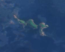
| Satellite image of the Bunker Islets taken by Sentinel-2 in 2016 | ||
| Waters | Foveaux Strait | |
| Geographical location | 46 ° 52 ′ S , 168 ° 16 ′ E | |
|
|
||
| Number of islands | 4th | |
| Residents | uninhabited | |
The Bunker Islets are a group of islands that belong to the northeast chain of the island collection of the Titi Islands in the Foveaux Strait of New Zealand . They are located 800 km southwest of the capital Wellington.
The uninhabited islands have a temperate climate. The average temperature is 6 ° C. The warmest month is January with 10 ° C and the coldest June with 3 ° C. The average rainfall is 1,347 millimeters per year. The wettest month is October with 183 millimeters of rain and the driest month of February with 64 millimeters.
Web links
- Bunker Islets, Southland on topomap.co.nz
Individual evidence
- ↑ Bunker Islets on Geonames.org , July 24, 1997, accessed July 25, 2020.
- ↑ NASA Earth Observations Data Set Index . NASA. Retrieved July 25, 2020.
- ↑ NASA Earth Observations: Rainfall (1 month - TRMM) . NASA / Tropical Rainfall Monitoring Mission. Retrieved July 25, 2020.
- ↑ based on the official TK of LINZ .

