Burgstall Heslach
| Burgstall Heslach | |
|---|---|
|
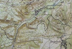
Map from the description of the Stadtdirections-Bezirk Stuttgart, 1856 |
|
| Castle type : | Hilltop castle |
| Conservation status: | Burgstall |
| Place: | Stuttgart - Heslach |
| Geographical location | 48 ° 45 '15.9 " N , 9 ° 8' 53.8" E |
The Postal Heslach is an Outbound hilltop castle in the hamlet dialed Böhmisreute southwest of the Stuttgart district Heslach . The square has been called " Burgstall " since the 19th century , to the north of which is "Burgstallstrasse" today. The castle has long since disappeared, the rock on which it stood erupted. A deep meaning leading ravine is called the "fire walk".
Individual evidence
- ^ Rudolph Moser: Description of the Stadtdirections-Bezirk Stuttgart.
