
Caer Bach
Coordinates: 53 ° 14 ′ 20 " N , 3 ° 52 ′ 59.1" W.

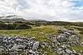
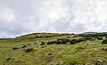
Caer Bach is a hillfort of indefinite age on a circular hill, northwest of the village of Rowen in Conwy , Wales . Its name means Little Fort. It is located at an altitude of about 413 meters on the eastern slopes of Tal-y-Fan, a peak of the Carneddau Mountains in northeast Snowdonia .
Little is known about its history as the site has hardly been investigated. The hill is bordered by two lines of defense. The outer one consists of an earth wall up to three meters high and an outer ditch. The inner one is a heavily looted stone wall between four and five meters wide. The badly damaged entrance ramp cuts both lines of defense on the southeast side. The outer circle delimits an oval area of approximately 78 × 66 meters, the inner an oval area of approximately 50 × 42 meters.
Nearby are the Maen y Bardd dolmen and Druid's Circle .
- Caer Bach
Stone wall of Caer Bach
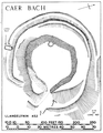
Layout
Wall


literature
- James Dyer: Hillforts of England and Wales . 1999, ISBN 0747801800 .
- James Ford-Johnston: Hillforts of the Iron Age in England and Wales: A Survey of the Surface Evidence . Liverpool University Press, Liverpool 1976.