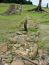
Camino Real de Castilla de Oro
The Camino Real in Panama was the most important trade route for the transport of gold and silver captured and exploited in South America during the Spanish colonial rule in Latin America. The Camino Real connected Panama City on the Pacific with Portobelo in the Caribbean (before Portobelo was founded in 1597 with Nombre de Dios ). It was around 80 kilometers long and was the shortest and topographically best-located connection between the two oceans. An alternative trade route was the Camino de Cruces, it led 30 kilometers overland from Panama City to Venta de Cruces (near the present-day town of Gamboa) on the banks of the Chagres River , after which the Chagres River was navigated to its mouth in the Caribbean. The expansion of the Camino Real began in the 1520s, but most sections of the path were only paved decades later.
With the end of the Spanish trade monopoly and the abandonment of the Portobelo trade fair in 1740, the path was hardly used. With the opening of the first transcontinental railway line between Colón , about 35 km west of Portobelo, and Panama City in 1855, the Camino Real became completely meaningless. The exact course is no longer known today.
location
The endpoints of the Camino Real and Camino de Cruces , the trade routes that crossed the Isthmus of Panama , were protected by forts. In Panama City on the Pacific, the city was re-founded in 1673 and surrounded by a city wall. In the Caribbean, fortresses were built at the end of the Camino Real in Portobelo and at the end of the Camino de Cruces at the mouth of the Chagres River (fortress San Lorenzo). Due to the arrangement of the endpoints of the trade routes and the riches transported over them, the area was called the "magic triangle".
Research project
In the last three decades it has been increasingly covered by suburbs due to urbanization in the outskirts of Panama City, or it was exposed by the deforestation of the rainforest and its conservation is now endangered. A research project has been exploring the exact course of the route since May 2008 and is developing a plan to preserve this cultural heritage .
Individual evidence
- ^ Edwin C. Webster: La Defensa de Portobelo. Editorial Universitaria, Panamá 1973. p. 49.

