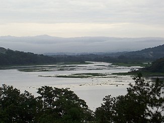
Río Chagres
| Río Chagres | ||
|
View of the Chagres River |
||
| Data | ||
| location | Panama | |
| River system | Río Chagres | |
| source | in the Cordillera de San Blas | |
| muzzle | in the Caribbean Sea Coordinates: 9 ° 19 ′ 7 ″ N , 80 ° 0 ′ 2 ″ W 9 ° 19 ′ 7 ″ N , 80 ° 0 ′ 2 ″ W |
|
| Mouth height |
0 m
|
|
| Reservoirs flowed through | Alajuela lake , Gatun lake | |
The Río Chagres (also called Río de Chagre or Río Chagre; German: Chagres river; named as "Río de los Lagartos", ie "River of the lizards", 1508 by Diego de Nicuesa and Alonso de Hojeda) is a in central - River located in Panama .
The Río Chagres, which rises in the Cordillera de San Blas at an altitude of around 600 above sea level, was an often sluggishly flowing body of water that quickly swelled into a torrent in the rainy season, initially in a south-westerly direction, but then in a large arc North flowed and flowed into the Caribbean Sea about 12 km southwest of Colón .
For the construction of the Panama Canal , the lower course was dammed by the Gatún dam between 1907 and 1913 to form the Gatúnsee (Spanish: Lago Gatún), which is 26 m above sea level . This represents the central part of the Panama Canal. At the same time, the Río Chagres supplies the water required to operate the canal locks. In order to avoid disruptions to the increasing shipping traffic caused by the untamed river and to have enough water for the lock operation even in dry periods, the Chagres river was dammed in the upper reaches of the Madden dam to the Alajuela lake in 1935 .
At long intervals, however, the Río Chagres carries so much water that both the Alajuela and Gatun lakes reach their maximum fill level. Shipping traffic on the Panama Canal had to be interrupted for 17 hours from December 8th to 9th, 2010 - for the third time in the 96-year history of the canal.
The catchment area of the Río Chagres is under the administration of the Panama Canal Authority (Autoridad del Canal de Panamá [ACP]), which not only operates the Panama Canal, but also electricity and 95% of the drinking water for the cities of Colón, Panamá, San Miguelito and in the future too Chorrera delivers.
The river was first explored by Diego Cueto and his helmsman Pedro de Umbria in 1506. In 1527, Hernando de la Serna was looking for a suitable place to build a canal through the Isthmus of Panama on behalf of the Spanish Crown ( Charles V ) . In the end, a new land connection (next to the Camino Real de Castilla de Oro ) was discovered, the Camino de Cruces . The route ran from old Panama to the city of Venta de Cruces. From there, the Atlantic could be reached by boat on the Chagres River. Today Venta de Cruces lies in the depths of the Gatunsee.
Individual evidence
- ↑ Note: For Spanish El lagarto (de Indias) , a name for the "American crocodile", the word derives Alligator from
- ^ Johann Jakob Egli : Nomina geographica. Language and factual explanation of 42,000 geographical names of all regions of the world. , Friedrich Brandstetter, 2nd ed. Leipzig 1893, p. 521
- ↑ Camino Real
- ^ The Panama Canal , by Colonel George W. Goethals
- ↑ NASA
- ↑ Article 316 of the Constitution of Panama
- ↑ Electricity u. ACP water supplies
- ↑ History of the Camino de Cruces ( Memento of the original from July 27, 2011 in the Internet Archive ) Info: The archive link was automatically inserted and has not yet been checked. Please check the original and archive link according to the instructions and then remove this notice.
