
CAPPI

CAPPI is a special display format for a weather radar . It is the abbreviation of C onstant A ltitude P lan P osition I ndicator and is a horizontal, two-dimensional representation of radar measured values at a certain height or altitude. A CAPPI is calculated and interpolated from several PPI measurements at various elevation angles (elevations). The different heights are usually represented by color variations on a plan position indicator . The radar reflectivity factor Z and the precipitation rate R are usually divided into 14 classes and displayed in color.
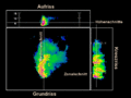
A Max-CAPPI (MAXimum-CAPPI) shows maxima of the CAPPI data from different heights. The Max-CAPPI display is generally used to provide an overview of the weather. This is done on the one hand by a vertical maximum projection in a floor plan, on the other hand by horizontal maximum projections from south to north or from west to east in side elevations. In the side cracks, the side scale indicates the height in kilometers. Mostly reflectivities are represented in a Max-CAPPI .
Another three-dimensional representation possibility Vol-CAPPI ( vol ume C onstant A ltitude P lan P osition I ndicator) mentioned. The view is similar to the Max-Cappi, but in contrast to this, it allows a clear echo assignment in all three cracks. An elevation (corresponds to a zonal section, i.e. a side elevation from east to west) is shown above the floor plan and a cross plan (corresponds to a meridional section, i.e. a side elevation from north to south) is shown next to the floor plan . With the help of a crosshair, the positions of these cuts can be selected as desired.
literature
- Patent US7821448 : Constant altitude plan position indicator display for multiple radars. Filed August 18, 2005 , published October 26, 2010 , applicant: Honeywell International Inc., inventor: Pravas R. Mahapatra, Vishnu V. Makkapati.
Structure of a full CAPPI display in a weather radar

CAPPI with a reflectivity display at an altitude of 1.5 km from Montreal ( Environment and Climate Change Canada )
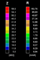
Radar intensity classes of a weather radar


