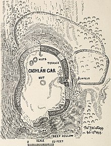
Cash mood Gar
The roughly kidney-shaped Hillfort Cashlaun Gar (also Cashlaungar ; Irish An Caisleán Gearr ) is located on a natural limestone rock at the entrance of the Glencurraun valley (at the bend of the eastern parallel road to the L1014 - near the Caislean Cave) in the east of the Burren in County Clare in Ireland .
description
The ramparts of the Hillfort are preserved in three places and are built from long machined blocks. In the northeast they reach their greatest height at just over four meters and a considerable thickness at 2.7 to 3.0 m. The gate opens to the edge of a steep 10 m high slope. At the foot of the slope there are stone fragments, probably the broken lintels of the gateway. Internally, the fort measures about 40 m from north to south and 23 m from west to east. On the north-west side of the dun lie the remains of three heavily damaged clochans . A fourth is in the middle across from the only gate in the east. The huts were probably thatched and not vaulted, as the walls are thin.
Lower fort
On the opposite edge of the plateau about 300 m from Cashlaun Gar, there is an irregular, diamond-shaped enclosure. The inner size is about 46 m from south to north and 40.5 m from east to west. The walls are only 0.9 to 1.8 m thick and about 1.5 m high. The SW corner is rounded. It can be a cattle pen.
Not far away is Cahercommaun, one of the largest inland promontory fort in Ireland.
literature
- Thomas Johnson Westropp: Prehistoric remains (forts and dolmens) in Burren and its south western border, Co.Clare. In. The Journal of the Royal Society of Antiquaries of Ireland, Ser. 6, 1915 Vol. V, pp. 45-62, pp. 249-274
- Peter Harbison : Guide to the Naional Monuments in the Republic of Ireland Gill and Macmillan, Dublin 1992 ISBN 0-7171-1956-4 p. 38
Web links
Coordinates: 53 ° 0 ′ 47.6 " N , 9 ° 4 ′ 46.8" W.

