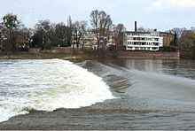
Cracauer waterfall
Coordinates: 52 ° 6 '53 " N , 11 ° 39' 24" O The Cracauer waterfall is an overflow weir in the elderly same in Magdeburg district Cracau .
Building
The weir completely blocks the flow through the Alte Elbe at low water levels and partially at medium water levels. This increases the amount of water flowing through the Stromelbe to the west of the Rotehorn Park and in the area of the cathedral rock .
The fixed weir consists of a concrete wall with an embankment on both sides. The crown length is 130 meters, the crown width 0.6 meters. The top of the weir is 43.17 m above sea level. NN. In the middle of the weir there is a 10.5 meter wide opening, a low water channel through which the water of the Elbe flows from a water level of 100 centimeters at the Magdeburg stream bridge . A maximum of 10 m³ / s of water flows through the low water channel before the weir is overflowed in full width from a water level of around 180 centimeters.
By changing the flow speed, the weir contributes to the formation of sand deposits in the Old Elbe, which hinder the access to the boat houses on the Old Elbe.
History of the weir
The Elbe changed its course several times in the Magdeburg area. From the 11th century to the 16th century, today's Stromelbe was the "Kleine Elbe", today's Alte Elbe the "Große Elbe" and today's "Taube Elbe" the old Elbe. From around 1550, the Kleine Elbe was called the Strom-Elbe. Until the construction of the first weir in 1684/86, the Great Elbe was used as a shipping route.
- In 1684/86 a first weir (called “Roste” or “Presterscher Sperrdamm”) was built at the junction of the Great Elbe from the Elbe at the Rothehornspitze. As a result, the Old Elbe and the Great Elbe were cordoned off and more water was fed to the previously shallow river Elbe. From then on, the river Elbe became a permanent shipping route in Magdeburg. The Great Elbe was renamed the Middle Elbe. The length of the weir was 375 meters, extended to 390 meters in 1739. From 1686 the crown height was 234 cm at the Magdeburg-Strombrücke gauge and was increased to 310 cm from 1707.
- In 1789/90, after being damaged in the spring flood of 1789, the first weir was replaced by a new dam ("Presterscher Sperrdamm") with a length of 550 meters and a height corresponding to 290 cm at the Magdeburg-Strombrücke gauge about 200 m below the first weir.
- In November 1806, French troops blew up the weir over a length of 50 m. This enabled the water of the Elbe to flow into the Alte Elbe again at all water levels, even at exceptional low water levels.
- In 1816/17 the weir was rebuilt ("Prestersches Richtewerk"). The overflow crest of the weir was again at 290 cm gauge Madeburg-Strombrücke. The crown length was 372 m and the crown width 5.5 m. The repaired weir served as a protective structure for the construction of the Cracauer weir.
- In 1819/20 the “Cracauer Weir” was built on the site of today's weir. It had an overflow length of 180 m and a width of 15.1 m. The height of the crest was initially 300 cm Magdeburg level and as a result of subsidence of the weir from 1842 it was 230 cm Magdeburg-Strombrücke level.
- In 1867/68 the Crackau weir was rebuilt due to subsidence of the weir crown. The length of the weir was now 126 m and the width of the crown 2.5 m. The overflow took place until 1877 at 163 cm at the Magdeburg-Strombrücke gauge, then from 178 cm. As with the first weir, a low water channel was built in, with a depth of 0.47 m and 6.5 m width.A low water channel, as in weir 1, was re-installed in the middle of the weir with a depth of 0.47 m and a width of 6.5 m Weir installed in order to allow a low flow through the Alten-Elbe even when the water level is below the weir crown.
- In 1968/69 the weir was given its shape that still exists today. The weeping crown was raised in order to compensate for the drop in water level in the river Elbe due to the more advanced bed erosion and to improve the navigation conditions.
(all level information: based on the current level of the Magdeburg-Strombrücke level)
Trivia
Until 1968 there was a crab trap at Cracau waterfall .
The Cracauer waterfall gave its name to the nearby " bridge at the waterfall ".
Before the construction of the bridge and during its renovation, the weir was used to cross the Old Elbe between Crackau and the Rotehornpark in times of low water. In 2017 the water police enforced a ban on this use.
literature
Manfred Simon: Investigations into anthropogenic impairment of the water levels at the Magdeburg-Strombrücke gauge. (pdf, 2.85 MB) PIK Report No. 118th Potsdam Institute for Climate Impact Research eV, September 14, 2010, accessed on June 24, 2020 .
Individual evidence
- ^ Katja Tessnow: Police control. Magdeburg bridge closed at the waterfall. In: Magdeburger Volksstimme. September 5, 2017, accessed June 25, 2020 .
