
Cramond Island
| Cramond Island | ||
|---|---|---|
 |
||
| Waters | Firth of Forth | |
| Geographical location | 55 ° 59 '35 " N , 3 ° 17' 23" W | |
|
||
| length | 540 m | |
| surface | 7.7 ha | |

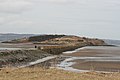
Cramond Island ( Scottish Gaelic Eilean Chathair Amain ) is a tidal island in the Firth of Forth . It is located about 1.6 km off the north coast of West Lothian between South Queensferry and the Edinburgh district of Cramond in Scotland . The oval island is 0.54 km long and 7.70 hectares in size.
The island is part of the Dalmeny Estate. Cramond Island is one of 43 tidal islands accessible on foot or by vehicle from mainland Great Britain and one of 17 in Scotland.
Cramond Island is connected to the mainland at low tide by the Drum Sands. A paved path allows access when the water is low. The dam runs alongside a series of concrete pylons that were erected as a submarine barrier during World War II and became an area attraction. At high tide , the dam is covered by the sea several meters high. The Coast Guard recommends that you only attempt the crossing during the two hours before and after low tide. The island lies in front of the mouth of the River Almond , which is adjacent to the landward end of the dam.
- Cramond Island
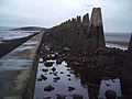
The dam at low tide
The dam at low tide

Aerial view

The dam at high tide


_-_panoramio.jpg)
