Cuchilla de Haedo
| Cuchilla de Haedo | |
|---|---|
|
Cuchilla de Haedo in the north |
|
|
Cerro Batoví in the Cuchilla de Haedo |
|
| location | Uruguay |
| Coordinates | 31 ° 41 ′ S , 56 ° 16 ′ W |
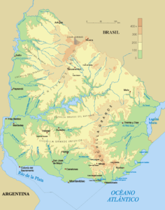
The Cuchilla de Haedo is a range of hills in Uruguay .
The Cuchilla de Haedo is located in the north of the country. This undulating plateau comprises several ranges of hills with gentle slopes that rarely reach heights above 400 m. The main relief runs from northeast to southwest and separates the water catchment basins of the Río Negro and the Río Uruguay . The Río Arapey and the Río Daymán have their source in the Cuchilla de Haedo .
summit
- Cerro Batoví ( 224 m )
- Cerro Bonito ( 351 m )
- Cerro Cementerio ( 255 m )
- Cerro de los Chivos ( 284 m )
- Cerro del Medio ( 221 m )
- Cerro Lunarejo ( 332 m )
- Cerro Miriñaque ( 282 m )
Web links
- Cuchilla de Haedo. In: Enciclopedia Geografica del Uruguay. Retrieved March 19, 2010 (Spanish).
- Cerro Bonito on Peakbagger.com (English)

