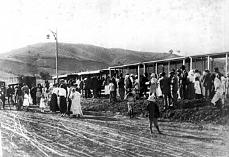
Yerba Buena steam tram
| Steam tram from Yerba Buena Tranvia rural a vapor de Yerba Buena |
|||||||||||||||||||||||||||||||||||||
|---|---|---|---|---|---|---|---|---|---|---|---|---|---|---|---|---|---|---|---|---|---|---|---|---|---|---|---|---|---|---|---|---|---|---|---|---|---|
|
Route
| |||||||||||||||||||||||||||||||||||||
| Route length: | 12 km | ||||||||||||||||||||||||||||||||||||
| Gauge : | 750 mm ( narrow gauge ) | ||||||||||||||||||||||||||||||||||||
|
|||||||||||||||||||||||||||||||||||||
The steam tram of Yerba Buena ( Spanish: Tranvia rural a vapor de Yerba Buena ) was a 12 km long steam tram in the Argentine city of Yerba Buena , which was inaugurated on June 29, 1916 to mark the centenary of Argentina's independence and shut down a decade later in 1926 has been.
Routing
The train drove from the station square, the Plaza Alberdi, then on the Calle Santiago del Estero heading west, turned right into the Avenida Miter and followed this until it turned left into the Avenida Manuel Belgrano. The depot and workshops were also here. From here she drove west again to Avenida Ejército del Norte. She then turned south until she continued west on Calle Córdoba (now Calle Don Bosco). On Calle Aconquija (today Calle Luis Federico Nougués) she drove to Avenida Mate de Luna, which she followed to the Horco Molle terminus at today's El Korte roundabout at the foot of the San Javier hill.
business
The train ran six to eight times a day. It was colloquially called "Trencito" (little train) or "La Chorbita" (the end of the puff). A simple drive through the suburbs, which were still rural at the time, took between 45 minutes and an hour. The stops were named with numbers, some of which are still used colloquially today.
Shutdown
Although a total of 135,505 passengers had been carried by 1925, rail operations were discontinued in 1926 due to a lack of profitability.
Web links
Individual evidence
- ↑ a b El chisporroteo de la chorbita mandó a vía muerta al “Trencito” de Yerba Buena.
- ^ Marta Barbieri and Matilde Silva: Historia del Municipio de Yerba Buena.
Coordinates: 26 ° 48 ′ 54.9 ″ S , 65 ° 13 ′ 10.5 ″ W.


