
Darling Harbor
Darling Harbor is a borough of Sydney , New South Wales , Australia . It is a large recreational area with numerous hotels, restaurants, shopping centers, theaters, museums and entertainment centers, which is largely designated as a pedestrian zone.
Darling Harbor is east of Sydney city center on both sides of Cockle Bay . It extends from Chinatown in the south to the height of Darling Point on Pyrmont Bay in the east and King Street Wharf in the west. Cockle Bay is just one of the many bays that make up the much larger Darling Harbor .

history
Darling Harbor is named after Ralph Darling , who was Governor of New South Wales from 1825 to 1831 . Originally, Darling Harbor was part of Sydney's commercial port with shipping berths, numerous warehouses, loading facilities, factories and its own rail connection.
During the Great Depression of the 1930s, the northern part of Darling Harbor and the adjoining Millers Point neighborhood , now known as Barangaroo , gained notoriety as The Hungry Mile . This goes back to the numerous dock workers who were looking for jobs in the area. In memory of that time, part of Hickson Road was officially renamed Hungry Mile in 2009.
In the 1960s, the Darling Harbor area began to deteriorate. Many port facilities and warehouses were no longer used and fell into disrepair. Since this resulting eyesore was in the cityscape near the city center and could be seen from the offices in the skyscrapers, the desire arose to redesign and reuse the port facilities.
At the beginning of the 1980s, the port facilities were demolished and the redesign and redevelopment of the district began. The first sections were completed in the late 1980s. The completion of all facilities and buildings in the further construction phases took until the end of the 1990s.
Work has been underway since 2007 on the redesign of the neighboring district of Barangaroo to the north, which, similar to Darling Harbor, is to be converted from a harbor district into a business and leisure district near the city center of Sydney.

Darling Harbor around 1900

View of Darling Harbor around 1900

Darling Harbor under renovation in the 1980s
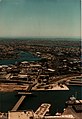
View from Center Point Tower over Darling Harbor during the redesign


today
Darling Harbor is one of the largest recreational and leisure areas in Sydney, which is very popular with both locals and tourists. Darling Harbor is home to many of the city's attractions. These include the Harborside Shopping Center, the Sydney Entertainment Center , the Powerhouse Museum , the Sydney Convention and Exhibition Center , the Sydney Aquarium , the Australian National Maritime Museum , the Sydney Wildlife World and the LG-IMAX -Cinema, which has the largest screen in the world.
Until June 2013, Darling Harbor was linked to Sydney city center by the Sydney Monorail , which circled the harbor basin. Five of the eight stations of the monorail were on the grounds of Darling Harbor.
Another important connection to the public transport system is through the ferries from Sydney, which operate a dock at the north end of Darling Harbor. From there there are connections to Circular Quay , an important transport hub in Sydney, and other suburbs of the city.

photos

View of the Harborside Shopping Center from the Pyrmont Bridge

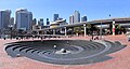
Cockle Bay Wharf on Darling Harbor
Darling Harbor

Darling Harbor

Darling Harbor at night


Web links
Coordinates: 33 ° 52 ′ 20.3 ″ S , 151 ° 11 ′ 56.3 ″ E