Decauville Railway Charlesville – Makumbi
| Charlesville-Makumbi | |||||||||
|---|---|---|---|---|---|---|---|---|---|
|
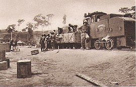
Freight train with a Decauville locomotive
| |||||||||
|
Route (1926–1955)
| |||||||||
| Route length: | 67 km | ||||||||
| Gauge : | 600 mm ( narrow gauge ) | ||||||||
|
|||||||||
The Decauville Railway Charlesville – Makumbi was a 67 kilometer long works - narrow-gauge railway with a gauge of 600 mm, which ran from 1926 to 1955 on the rapids of the Kasai river between Charlesville (today: Djokupunda ) and Makumbi in the Belgian Congo , today's Democratic Republic Republic of the Congo .
Route
Although the start and end stations are both on the Kasai River, the route did not run along its banks, but in an L-shape further east along today's RP706 road.
history
The mining company Forminière operated the narrow-gauge railway, which it built from May 1923 to October 1926, from 1926 to 1955. It used modern Deutz / Oberursel locomotives with internal combustion engines. They were probably equipped with robust single-cylinder benzene engines of the type ML322 or pre-chamber diesel engines with evaporative cooling of the type MAH322 .
Forminière was a forest and mining company founded in 1906 by Jean Jadot ( Société internationale forestière et minière du Congo ), which began mining diamonds in Kasai in 1913. In its heyday, Forminière was active in gold and silver mining, cotton, palm and rubber cultivation, in agriculture, in sawmill construction and even in its own shops. The Belgian colonial state had a 50% stake in the company's capital, with the rest being majority owned by American shareholders. During its entire existence, from 1913 to 1961, Forminière had a monopoly in Kasai. In 1959, Forminière's diamond production increased to 425,234 carats.
Railway operations ceased in 1955 and the diamond mines closed in 1960 after the independence of the Congo and the unrest in the region in 1960.
Individual evidence
- ↑ a b c WikiProject Congo-Kinshasa / Chemins de fer.
- ↑ Georges Arnaud: Les mines de diamant du Congo Belge. Annales de géographie Année 1925, No. 187, pp. 90–91.
- ↑ Route chronicle 1929.
- ^ A b Diamonds in Africa: Democratic Republic of Congo . Alluvial Exploration & Mining. Retrieved February 27, 2018.
- ↑ Un autre regard sur Tervuren - Guide alternatif de l'exposition ( Memento of September 27, 2007 in the Internet Archive ), Tony Busselen, International Action for Liberation, May 26, 2005.
Coordinates: 5 ° 48 ′ 48.2 ″ S , 20 ° 42 ′ 59 ″ E


