
Decauville Railway Narès – Inglis – Topçin – Vatiluk
| Narès – Inglis – Topçin – Vatiluk | |||||||||||||||||||||||||
|---|---|---|---|---|---|---|---|---|---|---|---|---|---|---|---|---|---|---|---|---|---|---|---|---|---|
.png) Bridge over the gorge of Vatiluk
| |||||||||||||||||||||||||
.jpg) Route, January 1, 1918
| |||||||||||||||||||||||||
| Route length: | 30-35 km | ||||||||||||||||||||||||
| Gauge : | 600 mm ( narrow gauge ) | ||||||||||||||||||||||||
|
|||||||||||||||||||||||||
The Decauville train Nares Inglis Topçin-Vatiluk was around 1916 a military - narrow-gauge railway in Greece .
Route
The 30-35 km long route network with a track width of 600 mm proceeded semicircle of Nares (today Nea Filadelfia , Νέα Φιλαδέλφεια) over Bumardza (now Bougaríevo , Μπουγαρίεβο), Sari-Omer (Σαρή Ομέρ) Inglis (now Anchialos , Αγχίαλος) and Topçin (today Gefyra , Γέφυρα) to Vatiluk (today Vathylakkos , Βαθύλακκος).
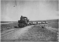
Near Topçin, June 1916

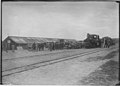
Inglis train station
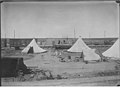
Tent camp
Railway station, Dec. 1916
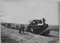
Decauville locomotive
._Le_Decauville_allant_sur_Top%C3%A7in.jpg)
._Gare_d%27Inglis.jpg)
._La_gare_02.jpg)
._La_gare.jpg)
._Le_Decauville.jpg)
See also
Web links
Commons : Decauville Railway Narès – Vatiluk - collection of images
Individual evidence
- ↑ Vatiluk (Kadikjöј). In: 3rd Military Mapping Survey of Austria-Hungary. ( Memento of January 3, 2010 in the Internet Archive ) Around 1910.
Coordinates: 40 ° 45 ′ 50.4 ″ N , 22 ° 42 ′ 0 ″ E