Accessibility map
An accessibility map is a true-to-scale, map-based representation of the accessibility of a location in relation to the area around it. At least one location is specified, to which the accessibility is determined for all other locations in the area. “Reaching” is generally used to denote the existence of a path or a route .
reachability
The term reachability relates in its basic form to the determination of whether two spatial positions can be reached in any permissible way . For example, the network of all public roads can be defined as permitted routes. By defining and restricting the "permissible routes", different technical statements can be generated and displayed in accessibility maps. For example, by specifying a maximum travel time (e.g. 30 minutes) to a location (e.g. train station) and a form of transport (e.g. on foot) in a corresponding accessibility map, what a traveler will do when staying with this map can be seen Time constraint could potentially visit.
Accessibility and travel time
The term "reachability" is often used in a figurative or extended sense, for example in the sense of "reachable within a defined maximum travel time". Here all spatial positions that lie within the defined maximum travel time are qualified with their specific travel time; all other spatial positions are classified as “not reachable”.
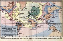
Accessibility maps are also used in the area of local public transport (“travel time maps” or travel time maps or isochronous maps ), in particular for assessing connection and travel options (see figure).
Accessibility maps can be used to obtain information about an area specific to the route network and means of transport. For example, the network of paths can be restricted to paths suitable for bicycles in order to classify an area with regard to its suitability for leisure activities.
Determination of availability
The accessibility of a given area is generally determined by non-directional searches within a given route network (as opposed to directed searches in routing). This means that routes to all other spatial positions are created and evaluated for a selected spatial position. It is therefore not the aim to determine a single optimal route between two spatial positions.
The road network can include road networks, public transport networks, pedestrian paths, rail connections, air traffic connections, etc. The calculation, taking travel time into account, can also take multimodal movement (e.g. on foot, by bicycle, by private car, public transport, etc.) into hybrid road networks ( multimodal traffic ) into account.
Areas of application
Accessibility maps are basic information for the determination and evaluation of spatial areas (geospatial analysis) with regard to spatial movement (or spatial mobility ) and spatial connection.
They allow, for example, an assessment of a location in the vicinity of which certain objects have to be visited within a given limit. For example, when selecting a location for a retail store, it can be determined whether certain other competing retail stores are within 15 minutes' walking distance. For example, the “family quality” of an apartment can also be determined by determining the presence of certain facilities (e.g. kindergarten, pediatrician, school, open spaces) and transforming it into a measure of the quality of the location.
Accessibility maps are basic elements in Motion Intelligence solutions.
See also
Web links
Individual evidence
- ↑ Accessibility maps to visualize the quality of mobility in public transport. Tassilo Glander, Martin Kramer, Jürgen Döllner: Kartographische Nachrichten, 2010.
- ↑ http://targomo.com

