Thematic map


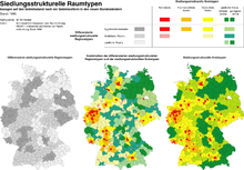
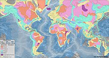
Thematic maps or applied maps are maps that illustrate a specific feature or topic, such as plant distribution or population density. Even relationships thematic levels can be prepared for. B. between features and their change over time.
In contrast to topographic maps (maps), which are primarily used for orientation in the terrain and the measurement of locations or geometric details, objects are shown in thematic maps "for knowledge of themselves". In addition to the factual reference , the time reference ( reference date or period ) and the spatial reference are the essential properties of a thematic map: the presented facts apply to a specific point in time or period and for a specific location or statistical spatial reference unit. Although topography itself is a topic, topographic maps have a special position. They form the basis for most of the thematic maps and also serve as the basis for planning purposes and research projects.
Thematic cards with a historical theme (a history theme) are called history cards . The term historical map , however, is ambiguous, as it is used for both old maps and history maps .
structure
Thematic maps can be divided according to different aspects:
- According to the subject area (see section “Subject areas of thematic maps”).
- According to scale ranges.
- In base and follow-up maps: Base maps are created through the direct cartographic transfer of existing measurements or observations. Follow-up cards present data that has already been processed in advance.
- According to the graphical representation method (see section "Graphical representation methods"). Numerous graphic variants can be used for the cartographic representation, which always have to be adapted to the topic, target information and data situation of the map. In particular, the following should be mentioned here: local signatures , diagrams , surface patterns , isolines , point scattering, area-true surface mosaics ( cartograms ).
- According to the spatial reference of the topic. In Diskreta, facts extend to a definable area (e.g. company locations), continua change in space (e.g. air pressure).
- Presentation of quantitative or qualitative content.
- Representation of static or dynamic content, i.e. illustration of the state of a situation at a fixed point in time or its temporal-spatial change.
- According to the degree of processing of the information presented (analytical, complex or synthetic maps).
The thematic maps also include the special form of the cartogram , whereby the positional accuracy of the facts shown is replaced by reference to fixed spatial units. There are also map-related representations such as topograms or particularly clear picture maps .
Graphic display methods
Basically, the geometric means of representation point , line and area are used. These can be combined with one another by creating graphic layers. Pointed elements and text are in the foreground, behind is the level of the line elements. The background is flat (exception when using transparencies).
- Position signatures (pictorial or geometric)
- Line signatures (variable in thickness, color, structure)
- Area signatures (color area, area pattern, hatching)
- Proportional signatures (variable in shape and color, scalable)
- Diagrams (different diagram forms are used)
- Isolines
- Point spread
- Movement signatures
- text
- Image elements
Subject areas of thematic maps
- Geology, geophysics and geomorphology (e.g. geological map , isogonal map )
- Soil science (e.g. soil map , appraisal map )
- Hydrography
- Meteorology and climatology (e.g. weather map , climate map )
- Plant and animal geography
- Landscape and ecology (e.g. degree of sunshine, risk of avalanches)
- Population and settlements
- Society, culture and history
- State, politics and administration (e.g. political map , postcode map )
- Economy including tourism (e.g. business cards)
- Routes: Access to a specific destination address with public transport / bike / car / truck, hiking maps , cycle route maps for tourism, orienteering or city cycling
- Transport including aviation, shipping (e.g. road map , aviation map , postal traffic map , logistics flows)
- Spatial structure (e.g. land map also called property map or cadastral map)
- Geomedicine
- Radioactivity from natural sources (mainly radon ), fallout after the Chernobyl nuclear disaster
- Military z. B. General staff map , measuring table sheet , situation map (all topographic maps at the same time )
- Planning system (e.g. marking map )
- Astronomy (e.g. star map , moon map )
Various graphic presentation methods and subject areas of thematic maps can be found in school atlases .
literature
- Günter Hake, Dietmar Grünreich, Liqiu Meng: Cartography. de Gruyter, Berlin / New York 2002, ISBN 3-11-016404-3 .
- Jürgen Bollmann, Wolf Günther Koch: Lexicon of cartography and geoinformatics . Spektrum Verlag, Heidelberg / Berlin 2001, ISBN 3-8274-1673-6 .
- Egon Breetz: Considerations on development trends in natural and thematic map design. In: Wiss. Magazine the PH Potsdam. H. 3/1985, pp. 459-469.
See also
Web links
Individual evidence
- ↑ Statistical spatial reference system: http://www.staedtestatistik.de/agk.html
- ↑ Günter Hake, Dietmar Grünreich: Cartography. 7th edition. Verlag de Gruyter, Berlin 1994.
- ↑ Egon Breetz: relief type cards "Haack Great World Atlas" - appropriate pattern of morphographic card type for geographic literacy. In: Wiss. Currently of the PH Potsdam. 18, 3, 1974, pp. 445-454.
- ^ Egon Breetz: Design problems of economic-geographical atlas and wall maps for geography lessons. In: Wiss. Currently of the PH Potsdam. 22, 3, 1978, pp. 371-390.
