
Cord (Eifel)
| coat of arms | Germany map | |
|---|---|---|

|
Coordinates: 49 ° 50 ' N , 6 ° 38' E |
|
| Basic data | ||
| State : | Rhineland-Palatinate | |
| County : | Trier-Saarburg | |
| Association municipality : | Trier country | |
| Height : | 140 m above sea level NHN | |
| Area : | 16.6 km 2 | |
| Residents: | 2143 (Dec. 31, 2019) | |
| Population density : | 129 inhabitants per km 2 | |
| Postal code : | 54306 | |
| Area code : | 06505 | |
| License plate : | TR, SAB | |
| Community key : | 07 2 35 069 | |
| Community structure: | 4 districts | |
| Association administration address: | Gartenfeldstrasse 12 54295 Trier |
|
| Website : | ||
| Local Mayor : | Medard Roth | |
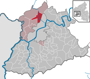
| Location of the local community Kordel in the district of Trier-Saarburg | ||
  |
||


Kordel , official spelling until May 15, 1936: Cordel is a municipality in the district of Trier-Saarburg in Rhineland-Palatinate . It belongs to the Trier-Land community . Kordel is a state-approved resort .
geography
Kordel lies in the Eifel on the Kyll River .
The districts of Burg Ramstein and Hochmark, the district of Kimmlingen, incorporated in 1953, and the residential areas of Kimmerbach, Kimmlingerhof, Ramsteinerbrücke and Reitzenmühle belong to the local community of Kordel .
history
A first documentary note of the place can be traced back to the year 1023. According to the prevailing opinion of local history researchers, an archbishop's estate contributed to the development of the name, which was called cordula or cortellum . According to historical manifestations, this episcopal estate was located near Ramstein Castle . The first documentary mentions of this property come from the year 1138.
Until the end of the 18th century the place belonged to the Electorate of the Palatinate . After the Left Bank of the Rhine was taken over by French revolutionary troops , the place belonged to the canton Pfalzel in the Saardepartement from 1798 to 1814 and became part of the Kingdom of Prussia in 1815 on the basis of the agreements made at the Congress of Vienna . In 1816 the community was assigned to the district of Trier and from 1822 it belonged to the Rhine province .
- Population development
The development of the population of the municipality of Kordel in relation to today's municipality, the values from 1871 to 1987 are based on censuses:
|
|
Municipal council
The local council in Kordel consists of 16 council members, who were elected in a personalized proportional representation in the local elections on May 26, 2019 , and the honorary local mayor as chairman.
The distribution of seats in the local council:
| choice | SPD | CDU | FWG * | total |
|---|---|---|---|---|
| 2019 | 3 | 3 | 10 | 16 seats |
| 2014 | 3 | 3 | 10 | 16 seats |
| 2009 | 3 | 3 | 10 | 16 seats |
| 2004 | 4th | 3 | 9 | 16 seats |
| 1999 | 6th | 5 | 5 | 16 seats |
* FWG = Free Voting Group Kordel e. V.
Attractions
Ramstein Castle and the Genoveva Cave are located near Kordel . In front of this cave, flint fragments and scrapers from the older Stone Age as well as stone axes and spearheads from the Younger Stone Age were found.
In addition, parts of the Roman long wall can be identified on the parish of the local community.
The Butzerbach Falls are located near the castle , a series of waterfalls over red sandstone banks that are accessed by a path with a 30-meter-long net bridge.
Transportation
The station cord is located at the Eifel track Cologne - Euskirchen -Gerolstein- Trier . The following local rail passenger trains operate under the brand name VAREO :
| line | designation | Line course | Clock frequency |
|---|---|---|---|
| RB 22 | Eifel Express |
Cologne Fair / Deutz - Cologne - Euskirchen - Jünkerath - Gerolstein - Bitburg-Erdorf - Kordel - Ehrang - Trier (Cologne Fair / Deutz - Gerolstein asRE 22) |
60 min (in the HVZ amplifier Gerolstein – Trier) |
Vehicles from the 620 and 622 series are used . The tariff of the Verkehrsverbund Region Trier (VRT) applies .
Due to the good rail connection and the relatively difficult accessibility on the road, Kordel is not approached by public buses at all.
Web links
- To search for cultural assets of the Kordel community in the database of cultural assets in the Trier region .
- Link catalog on the topic of cord at curlie.org (formerly DMOZ )
Individual evidence
- ↑ a b State Statistical Office of Rhineland-Palatinate - population status 2019, districts, municipalities, association communities ( help on this ).
- ↑ Statistics of the German Reich, Volume 450: Official municipality directory for the German Reich, Part I, Berlin 1939, p. 268.
- ↑ a b State Statistical Office Rhineland-Palatinate - regional data
- ↑ State Statistical Office Rhineland-Palatinate (ed.): Official directory of the municipalities and parts of the municipality. Status: January 2018 [ Version 2020 is available. ] . S. 79 (PDF; 2.2 MB).
- ^ Regional Returning Officer Rhineland-Palatinate: Local elections 2019, city and municipal council elections
- ↑ Deutsche Bahn course book. Retrieved September 25, 2018 .

Aach | Ayl | Baldringen | Bekond | Notification | Beuren (high forest) | Bonerath | Damflos | Detzem | Ensch | Farschweiler | Fur | Fish | Pine | Franzenheim | Freudenburg | Geisfeld | Greimerath | Grimburg | Gusenburg | Gusterath | Gutweiler | Heddert | Stalling | Herl | Hermeskeil | Hinzenburg | Hinzert-Pölert | Hockweiler | Holzerath | Hedgehog | Irsch | Kanzem | Chasuble | Kastel-Staadt | Kell am See | Kenn | Kirf | Klüsserath | Conc | Cord | Korlingen | Köwerich | Lampades | Langsur | Leiwen | Lunge | Longuich | Lorscheid | Mandern | Mannebach | Mehring | Mertesdorf | Merzkirchen | Morscheid | Naurath (Eifel) | Naurath (forest) | Neuhütten | Newel | Nittel | Upper cheap | Ockfen | Ollmuth | Onsdorf | Osburg | Palzem | Paschel | Pellingen | Pluwig | Pölich | Ralingen | Swift oath | Reinsfeld | Riol | Riveris | Saarburg | Schillings | Schleich | Schoden | Schömerich | Schondorf | Schweich | Serrig | Sommerau | Taben-Rodt | Tawern | Temmels | Thomm | Thörnich | Trassem | Trierweiler | Trittenheim | Vierherrenborn | Waldrach | Waldweiler | Wasserliesch | Wawern | Waves | Welschbillig | Wiltingen | Wincheringen | Zemmer | Zerf | Züsch