
Fort Blucher

The Fort Blücher lies opposite the town of Wesel in the district of Büderich , where it holds the function of a bridgehead for Wesel road bridge over the Rhine one.
history
Fort Blücher was built from 1807 to 1813 under the name of "Citadelle Napoleon" under Napoléon Bonaparte . After a six-month siege of the fortress Wesel , the citadel was finally occupied by Prussian troops and later rebuilt with the new direction of battle against the west based on the plans of the fortress engineer Gotthilf Benjamin Keibel . The fort finally got its current name after Field Marshal Blücher .
Towards the end of the Second World War there was fighting over the fort when 200 German soldiers covered their retreat across the Rhine and also holed up in Fort Blücher.
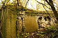
After the destruction in World War II and the unfortunate reconstruction of the Rhine bridge for the fort, only the ruins of the defenses barracks remain as the last relic. Today it is considered the largest known winter quarters for bats in the Wesel district. In 2008, the remains of the old Napoleonic buildings were found and examined during construction work.
Fort Blücher military cemetery

The final resting place of the dead in the Fort Blücher military cemetery is on the edge of the Büderich cemetery.
gallery
- Fort Blucher

Fort Blücher 2013
Fort Blücher Wesel

Fort Blücher Wesel

Fort Blücher Wesel

Fort Blücher Wesel

Fort Blücher Wesel inside

Fort Blücher Wesel inside 2013


Web links
- Presentation of the fortress Wesel on Fortified-Places.com
Individual evidence
- ↑ Fort Blücher. (No longer available online.) In: clivia.belta.de. May 20, 2010, archived from the original on November 27, 2015 ; Retrieved November 26, 2015 . Info: The archive link was inserted automatically and has not yet been checked. Please check the original and archive link according to the instructions and then remove this notice.
- ↑ Petra Herzog: Now come the archaeologists. In: derwesten.de. April 15, 2008, accessed November 26, 2015 .
Coordinates: 51 ° 38 ′ 37.4 " N , 6 ° 35 ′ 51.1" E