Fort canning
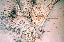
Fort Canning ( fortress Canning ) in Singapore , a military fortress of the 19th and 20th centuries still in existence today , is located on the almost 50 meter high Fort Canning Hill (now also Fort Canning Park ), formerly Government Hill or . Singapore Hill or Bukit Larangan (Malaysian for Forbidden Hill) called. The fortress is located in the Central region . The history of the fortress goes back to the 14th century. In the 20th century, Fort Canning Bunker , now known as The Battle Box, was located on the site of the fortress .
Early history
The history of the fortress goes back to at least the 14th century, when the area on the north bank of the Singapore River, known as Temasek (also Temasik, German for "Seestadt"), with the settlements of Banzu (also Ban Zu) and Long Ya Men was to be found; Temasek was the name that was used either only for the port or for the entire island. The area is mentioned as early as 1330 by a Chinese traveler: Wang Dayuan described his travels in Asia, including Singapore, in his travelogue Daoyi Zhilüe . The ruler of this area, called Sri Tri Buana, decided to name his island kingdom the Kingdom of Singapura (Singapura, also Singa Pura, in Sanskrit roughly means "Lion City"), as the city was also called. The center of this kingdom was apparently around today's Fort Canning Hill, where the population settled on the north bank of the river, the hill itself was reserved for the ruling elite, who also built a palace there. There are indications that at least the hill had fortress-like defenses. A royal burial site was later established here, which gave rise to the Malaysian name Bukit Larangan or "Forbidden Hill" (this name lasted until 1822). Remains of the former buildings and the settlement were still visible in 1820.
19th century (creation of the fortress)
After Singapore was incorporated into the British Empire, a residence for Sir Raffles was built on the hill in 1819/1822 and later renamed the Government House. The hill has since been called Government Hill (sometimes also Singapore Hill). In 1859 the government house was demolished to make way for the construction of an artillery fortress. The fortress was completed in 1861 and named after the first Viceroy of India , Charles Canning .
Fort Canning was finally demolished in 1907 without ever being used for its purpose, the defense of Singapore. The fortress turned out to be a bad plan: attacking warships could have come close enough to destroy the city with cannons without getting within range of the fortress guns. In addition, the fortress had no fresh water sources. The 17 guns that were erected in the 1860s are no longer available; the two that are on the site today come from another fortress.
Fort Canning Bunker, Battle Box
Long before the outbreak of World War II , the British Army decided to set up a headquarters for the Malaya Command in Singapore. The headquarters of the Singapore Base District , known as Headquarters Malaya Command Operations Bunker ("The Canning Fort Bunker" for short, now "The Battle Box"), was built from 1936 and completed in 1941. It was an operations center, consisting of an underground room and tunnel system. The bunker comprised about 20 rooms and had an encryption and planning room, a telephone and signal center, control center for the guns, and it had a power generator and a ventilation system. The bunker was built to be bomb-proof and flood-proof and was located at a depth of nine meters.
After the Japanese occupation of Singapore on February 8, 1942, all objects in the Fort Canning Bunker were burned in a campfire on February 14, 1942. After the surrender on February 15, 1942, the Japanese army moved into the bunker. After the Japanese surrendered in 1945, the British decided to seal the bunker, and when Singapore gained independence in 1963, they handed it over to the Singaporean military (SAF) . After that, the site was not used for a long time, until the idea of building a memorial here was examined in 1988. Since January 31, 1992, the area served as a tourist attraction, the Battlebox was made accessible as a museum on January 15, 1997 after a restoration. After being closed from 2013 to 2016, it reopened as the Battlebox Visitor Center and was named the best museum in Singapore in 2017.
Remarks
- ↑ One source mentions the year 1926 here, cf. battlebox.com.sg / ...
Individual evidence
- ↑ Derek Heng Thiam Soon: Reconstructing Banzu, a fourteenth-century Port Settlement in Singapore , ed. by: Malaysian Branch of the Royal Asiatic Society, in: Journal of the Malaysian Branch of the Royal Asiatic Society , 2002/1, pages 69–90, JSTOR 41493463 (restricted access )
- ↑ Singapore River Walk , publication of the state National Heritage Board , online at: roots.sg / ... , 85 pages, here page 4
- ↑ a b Vernon Cornelius-Takahama: Fort Canning Park , in: Infopedia, Server of the National Library Board, Singapore Government, online at: eresources.nlb.gov.sg / ...
- ↑ Construction of Fort Canning Beginns , in: History SG, Server of the National Library Board, Singapore Government, online at: eresources.nlb.gov.sg / ...
- ↑ Gretchen Liu: Singapore: A Pictorial History, 1819-2000 , Psychology Press, 2001, 400 pages, here page 55, online at: books.google.de / ...
- ↑ a b Wong Heng: Fort Canning Bunker (The Battlebox) , in: Infopedia, Server of the National Library Board, Singapore Government, online at: eresources.nlb.gov.sg / ...
- ↑ Harfield AG: Fort Canning, Singapore , in: Journal of the Society for Army Historical Research , vol. 39 (1961), no. 159, JSTOR 44223354 (restricted access )
- ↑ a b The Battlebox Story , chronological overview of the museum "Battlebox Visitors Center", online at: battlebox.com.sg / ...
Web links
Coordinates: 1 ° 17 '38.7 " N , 103 ° 50' 48.2" E

