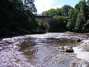
Gilnockie Bridge
Coordinates: 55 ° 5 ′ 39 " N , 2 ° 57 ′ 50" W.
| Gilnockie Bridge | ||
|---|---|---|
| use | Road bridge | |
| Convicted | Back road | |
| Subjugated | Esk | |
| place | near Canonbie | |
| construction | Stone arch bridge | |
| overall length | 74 m | |
| Number of openings | 2 | |
| Clear width | 21 m | |
| Clear height | 14 m | |
| completion | 1793 | |
| location | ||
|
|
||
The Gilnockie Bridge is a road bridge near the Scottish town of Canonbie in the Council Area Dumfries and Galloway . In 1971, the building was initially included in the Scottish monument lists in category B. The upgrade to the highest monument category A took place in 1988.
description
The masonry viaduct is located around two kilometers north of Canonbie near the Tower House Gilnockie Tower . It leads an unspecified side road over the Esk , which marks the border between Scotland and England for a short distance a few kilometers downstream. Before the A7 was straightened , this important trunk road ran over the bridge.
The arch bridge built in 1793 spans the Esk with a round arch . Another round arch leads exclusively over land. The arches have clear widths of 21 m with clear heights of 14 m. The bridge has a total length of 74 m. In the middle of the 20th century the carriageway was widened. The plain steel railing is more recent.
Individual evidence
- ↑ a b Listed Building - Entry . In: Historic Scotland .
- ↑ Entry on Gilnockie Bridge in Canmore, the database of Historic Environment Scotland (English)
Web links
- Entry on Gilnockie Bridge in Canmore, Historic Environment Scotland database


