
River Esk (Solway Firth)
| Esk | ||
 The Esk in Langholm |
||
| Data | ||
| location | Dumfries and Galloway , Cumbria , United Kingdom | |
| River system | River Esk (Solway Firth) | |
| Drain over | Solway Firth → Irish Sea | |
| River basin district | Solway Tweed XRBD | |
| source | Confluence of Black Esk and White Esk near Castle O'er 55 ° 12 ′ 21 ″ N , 3 ° 10 ′ 29 ″ W |
|
| Source height | 149 m ASL | |
| muzzle | Estuary in the Solway Firth Coordinates: 54 ° 57 ′ 22 " N , 3 ° 10 ′ 53" W 54 ° 57 ′ 22 " N , 3 ° 10 ′ 53" W |
|
| Mouth height | 0 m ASL | |
| Height difference | 149 m | |
| Bottom slope | 4.3 ‰ | |
| length | 35 km | |
| Left tributaries | Meggat Water , Ewes Water , Tarras Water , Liddel Water , River Lyne | |
| Right tributaries | Logan Water | |
The Esk is a river in the Scottish council area Dumfries and Galloway and the English county of Cumbria .
course
The river is created by the confluence of the White Esk with the Black Esk near the village of Castle O'er at an altitude of 149 m. Initially flowing to the east, the Esk describes a wide semicircle clockwise on its 35 km long course. Finally flowing to the west, it forms with its confluence with the Eden the head of the Solway Firth , which finally widens to a bay and merges into the Irish Sea .

The White Esk just before the mouth

The Black Esk

Confluence of the Esk and Eden to the Solway Firth


The Esk flows through a sparsely populated region of Dumfries and Galloways. Bentpath , Langholm and Canonbie are among the villages along the Esk in Scotland. With the confluence of Liddel Water south of Canonbie, the Esk forms the border between Scotland and England for around 800 m. In the English county of Cumbria the Esk flows through Longtown , then opens south of Gretna to the Solway Firth and again forms the Scottish-English border.
Tributaries
The Esk takes on numerous streams along its course. The most important left tributaries include the Ewes Water in Langholm, the Tarras Water south of Langholm, the Liddel Water south of Canonbie and the Lyne between Longtown and its mouth. Wauchope Water also flows into the Esk from the right in Langholm .
bridges
With the A7 and the M6, in addition to numerous secondary roads, two trunk roads cross the Esk. In Scotland, the Gilnockie Bridge , the Bentpath Bridge , the Duchess Bridge and the Skipper's Bridge alone lead four bridges from the highest monument category A across the Esk.
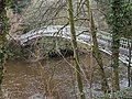
Duchess Bridge near Langholm


Web links
Individual evidence
- ↑ a b Esk in: FH Groome: Ordnance Gazetteer of Scotland: A Survey of Scottish Topography, Statistical, Biographical and Historical. Grange Publishing, Edinburgh 1885.
- ↑ a b c Entry in the Gazetteer for Scotland
- ↑ Listed Building - Entry . In: Historic Scotland .
- ↑ Listed Building - Entry . In: Historic Scotland .
- ↑ Listed Building - Entry . In: Historic Scotland .
- ↑ Listed Building - Entry . In: Historic Scotland .