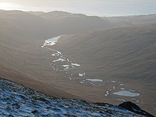
Glen Iorsa
Glen Iorsa is the largest valley on the Scottish island of Arran . Starting at Loch na Davie about six kilometers northwest of the summit of Goat Fell at a height of 360 m in a south-westerly direction to just before Kilbrannan Sound near Dougarie on the west coast of Arran. In the course of the approximately 13.5 km long valley there are numerous small lakes, of which Loch Iorsa is the largest, as well as the brook Iorsa Water . From the west, two gorges flow into Glen Iorsa and several mountain streams flow into Iorsa Water.
Glen Iorsa runs through a remote landscape and there are no permanently inhabited dwellings. Through and around Glen Iorsa there are various hiking routes with different levels of difficulty. The closest settlement is Dougarie.
Individual evidence
- ↑ Gleniorsa. In: Francis H. Groome: Ordnance Gazetteer of Scotland: A Survey of Scottish Topography, Statistical, Biographical and Historical. Volume 3: (Edr - Har). Thomas C. Jack, Grange Publishing Works, Edinburgh et al. 1885, p. 187 .
- ^ Paddy Dillon: Walking on the Isle of Arran. 2nd Edition. Cicerone, Milnthorpe 2006, ISBN 978-1-852-84478-3 .
Coordinates: 55 ° 37 ′ 20 ″ N , 5 ° 16 ′ 30 ″ W.
