
Grepault


Grepault is a Bronze Age and Iron Age settlement in the municipality of Trun in the Swiss canton of Graubünden .
location
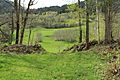
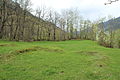
The rocky hill Grepault ( Rhaeto-Romanic for high rock ) is located on the south bank of the Vorderrhein opposite the village of Darvella. At a distance of around 200 meters on the other side of the river, graves and house floor plans from the Bronze and Iron Ages were found in several excavations.
To the north, the hill drops steeply over 50 meters to the Rhine. The Grepault is also separated from its surroundings by steep rock faces to the east and partly to the west. The hilltop drops in several stages from south to north. Access to the flat plateau is via a ramp on the flatter south side.
investment

The remains of the wall that are still visible today date from the early Middle Ages . An enclosure wall with a gate opening on the south side runs along the southern and western edge of the plateau. A short traverse branches off at the southwest corner, which is also still visible.
In 1943, the foundation walls of an early medieval church were excavated on the eastern edge of the plateau: an east-facing , simple hall with an apse growing out of the side walls . A smaller rectangular building was attached to the south. The facility on Grepault was therefore a small church fort in the early Middle Ages, which was abandoned for unknown reasons in pre-Carolingian times. A conversion into a feudal castle like the Jörgenberg or Castrisch did not take place. The sparse finds from recent times suggest that the complex was only temporarily inhabited.

Foundation walls of the church

Remnants of the curtain wall
Entrance from the inside
View to the west, in the foreground the church walls


Digs
Walo Burkart was the first to examine part of the hill plateau in 1931/34. He came across traces of a house floor plan and ceramic fragments from the younger Iron Age . At the same time, he established several settlement horizons. In 1955, master chimney sweep Tobias Deflorin (1903–1977) excavated a stove on the first terrace below the plateau, although it could not be precisely dated; a period in the early Middle Ages is assumed. In 1957, Hercli Bertogg (1903–1958) had an exploratory trench dug from the northern fall to the plateau, and a year later Deflorin found a winged needle from the early Bronze Age.
The last for the time being, Hans Erb (1910–1986) carried out emergency excavations on the northern edge in 1959/60, as the northern edge of the plateau was to be blasted off. Objects from different epochs of the Bronze Age (ceramics, daggers) and the early Iron Age (ceramics, glass ring fragments) were recovered. A few scattered finds come from the Roman Empire. A robe pin from the 5th or 6th century indicates connections with the southern and eastern Alpine region at the time of Ostrogoth rule. After the 7th / 8th There are no traces of further occupancy in the 19th century.
literature
- Clavadetscher / Meyer: The Burgenbuch von Graubünden , Orell Füssli, Zurich 1984, p. 353
- Handbook of Graubünden history. Volume 1. Verlag Bündner Monatsblatt, Chur 2005, p. 74.
- Andreas C. Zürcher: Prehistoric sites in Graubünden. Series of publications by the Rätisches Museum, No. 27. Chur 1982, p. 46.
Web links
Individual evidence
- ↑ Ernst Probst: Switzerland in the Middle Bronze Age, p. 57