Guthega Pondage
| Guthega Pondage | |||||||||
|---|---|---|---|---|---|---|---|---|---|
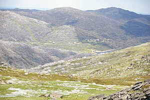
| Guthega and Guthega Pondage from Mount Tate | |||||||||
|
|||||||||
|
|
|||||||||
| Coordinates | 36 ° 22 '45 " S , 148 ° 22' 10" E | ||||||||
| Data on the structure | |||||||||
| Construction time: | 1955 | ||||||||
| Data on the reservoir | |||||||||
| Altitude (at congestion destination ) | 1585 m | ||||||||
| Water surface | 26 ha | ||||||||
| Reservoir length | 1.8 km | ||||||||
| Reservoir width | 250 m | ||||||||
The Guthega Pondage is one of the 15 in the Snowy Mountains Scheme accumulated power generation artificial lakes. The lake is essentially fed by the Snowy River , which flows west of the Snowy Mountains in New South Wales , Australia . The Guthega settlement above the reservoir can be reached from Jindabyne via a side street of the cul-de-sac to the Charlotte Pass (distance approx. 33 km). The Guthega Pondage is 1585 m high and thus already above the tree line .
In addition to the Snowy River, two streams also flow, u. a. the Spencer's Creek , into the reservoir.
Web links and sources
- Guthega Dam . SnowyMountainsFishing.com.au
- Snowy Rivers Environmental Flow . Environment.nsw.gov.au
- Map of Guthega Pondage, NSW . Bonzle.com
- Spencers Creek & Snowy River to Guthega Pondage 2010 Video . BlingCheese.com
- Steve Parish: Australian Touring Atlas . Steve Parish Publishing Pty. Ltd. Archerfield QLD (2007). ISBN 978174193232-4 . P. 34


