
Hubersee (Penzberg)
| Hubersee | ||
|---|---|---|

|
||
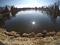
| View from the east, in the foreground a protected litter meadow | ||
| Geographical location | Penzberg , Weilheim-Schongau district | |
| Tributaries | (without) | |
| Location close to the shore | Penzberg | |
| Data | ||
| Coordinates | 47 ° 45 ′ 46 ″ N , 11 ° 21 ′ 0 ″ E | |
|
||
| Altitude above sea level | 610 m | |
| surface | 9 ha | |
| length | approx. 400 m | |
| width | approx. 300 m | |
| Maximum depth | 3 m | |

The Hubersee , also called Hubsee or Huberer Weiher, is a lake that was created from a dead ice hole west of Penzberg . It takes its name from the neighboring Gut Hub (short for Gut Huber), a former farm with 99 hectares of land, on whose grounds the lake is located.
geography
The lake - it is a maximum of three meters deep in the middle - is fed by underground springs ( pools ) and from the groundwater of the surrounding moor area. Together with the Strangenweiher , the Kirnbergsee and Inselweiher , it forms a small group of lakes. The ponds have no natural inflows or outflows, but are artificially connected and are fed by the Huber lake and groundwater. There is a campsite in the middle of the lake group. Strandweiher and Inselweiher are used for fish farming.
Trivia
The edge of the lake group is planned by the city of Penzberg as a location for a future four-star hotel. A project that was prevented by two referendums. To protect against flooding, the drainage of the Strangenweiher is being discussed, because the Weilheim water management office sees the Kochelseebahn track, which is about 150 meters away, at risk in the event of extreme flooding .
Kirnbergsee

Strandweiher (background) and Inselweiher (foreground)


Web links
Individual evidence
- ↑ More tents on the campsite. In: sueddeutsche.de. October 9, 2017, accessed August 23, 2018 .
- ↑ http://www.fischwaid-penzberg.de/j/index.php/vereinsgewaesser
- ↑ https://www.dasgelbeblatt.de/lokales/penzberg/angler-sind-entsetzt-stadt-will-strangenweiher-trocken-legen-9267072.html