Isbjørnhamna
| Isbjørnhamna | ||
|---|---|---|
|
View into the Hordsund from the southwest, Isbjörnhamna in the foreground on the left |
||
| Waters | Greenland Sea ( Arctic Ocean ) | |
| Land mass | Spitsbergen | |
| Geographical location | 77 ° 0 '6 " N , 15 ° 34' 39" E | |
|
|
||
| width | 1.5 km | |
| depth | 700 m | |
|
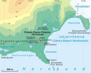
Map of the bay |
||
Isbjørnhamna ("Isbjørnhafen") is a bay on the north coast of Hornsund , a fjord on the island of Spitsbergen in the southern Wedel-Jarlsberg country .
geography
The bay, which opens to the southeast, is framed by the headlands Wilczekodden in the southwest and Baranowskiodden in the northeast. It is 1.5 km wide and 700 m deep. There are several small islands in the bay. The bank is occupied by the Fuglebekken in the north and the Fuglebergsletta coastal plain in the west. The mountains Fugleberget (569 m) and Ariekammen (513 m) tower behind it .
history
The name of the bay is reminiscent of the Norwegian sailing yacht Isbjørn ("polar bear"), the ship of an Austrian expedition that visited and explored the Hornsund in 1872. The leader and financier of the expedition was Johann Nepomuk Graf Wilczek , captain of the ship Maximilian Daublebsky von Sterneck . From 1908 there was a trapper's hut on the bay . In the 1930s, the polar bear hunter Wanny Woldstad also wintered here . A Polish research station has been located on the western bank of the bay since 1957 .
Individual evidence
- ↑ Isbjørnhamna . In: The Place Names of Svalbard (first edition 1942). Norsk Polarinstitutt , Oslo 2001, ISBN 82-90307-82-9 (English, Norwegian).
- ↑ Wolfgang Pillewizer : Glacier land in the Arctic. Brockhaus, Leipzig 1967, p. 149 ff.
- ↑ Isbjørnhamna - Polish Polar Station . In: Cruise Handbook for Svalbard , Norwegian Polar Institute 2008 (English)


