Jewish cemetery (Neustadt in Holstein)
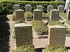
The Jewish cemetery of Neustadt in Holstein lies within the Evangelical Neustadt cemetery, which encloses it on three sides. It was occupied from 1945 to 1947. There are around 100 tombs of the victims of the Cap Arcona disaster of May 3, 1945, of former concentration camp inmates and of those who died in the nearby Displaced Persons Camp (DP camp) in Neustadt.
description
The Jewish cemetery forms an independent cemetery area within the Protestant Neustädter Friedhof, bordered by a brick wall and hedge. The area is about 15 meters wide and 20 meters long. There is a memorial stone on the side opposite the entrance. The women are buried to the left and the men to the right. In the rearmost part of both the women's and the men's section there are a few graves that have no names but only concentration camp numbers. The tombstones are largely uniform.
history
The cemetery was inaugurated on January 5, 1947. The German inscription on the central memorial stone documents that most of those buried here died on May 3, 1945, the day Neustadt was liberated by the British military. On May 3, before the Cap Arcona was bombed, prisoners from the Stutthof concentration camp were shot on land. Those who died in the following two years were inmates of the large DP camp for former concentration camp prisoners that existed in Neustadt at the time. Many of the inmates died as a result of the health problems they had suffered during the concentration camp. About 100 burials were carried out in the cemetery. The tombstones date from May 3, 1945 to 1947.
Web links
Individual evidence
- ↑ a b List of monuments in Ostholstein. In: www.schleswig-holstein.de. State Office for Monument Preservation, accessed on February 12, 2020 .
- ^ The Jewish cemetery in Neustadt (Ostholstein district). Retrieved February 12, 2020 .
- ^ Museum Cap Arcona / Neustadt in Holstein. Retrieved February 12, 2020 .
- ↑ AKENS Informations 33/34, Jochims: "Lübeck is only a short stop on the Jewish hiking trail". Retrieved February 12, 2020 .
Coordinates: 54 ° 6 ′ 28.2 " N , 10 ° 49 ′ 34.3" E

