Kamešnica (mountains)
| Kamešnica | ||
|---|---|---|
|
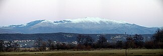
Snow-covered Kamešnica with a peak Konj |
||
| Highest peak | Konj ( 1856 m. I. J. ) | |
| location | Bosnia-Herzegovina / Croatia border | |
| part of | Dinara , Dinarides | |
|
|
||
| Coordinates | 43 ° 43 ' N , 16 ° 52' E | |
| particularities | z. T. untouched ecosystem | |
The Kamešnica is a mountain range partly in western Bosnia-Herzegovina and partly in Croatian Dalmatia . As the foothills of the Dinara Mountains , it extends from the northwest at Vaganj (1173 m) to the Buško jezero reservoir . Most of the Kamešnica and the Konj (German horse) belong to Bosnia-Herzegovina , the highest point of which is 1856 m above sea level. M. On a clear day, it offers an excellent view of Bosnia and Croatia, even Adriatic islands are visible.
Because of the geographical conditions, the Kamešnica populate many different animal species. It has many hiking trails and some deep caves . In the northern part the ecosystem is completely preserved, which is due not least to the inaccessibility of this area. In addition, the mountains are mostly surrounded by dense forest. Six to seven months of the year its highest parts are covered with snow.

